IMAGES TAKEN NEAR TO
Clayhill Field, WIGSTON, LE18 3UU
Introduction
This page details the photographs taken nearby to Clayhill Field, LE18 3UU by members of the Geograph project.
The Geograph project started in 2005 with the aim of publishing, organising and preserving representative images for every square kilometre of Great Britain, Ireland and the Isle of Man.

There are currently over 7.5m images from over14,400 individuals and you can help contribute to the project by visiting https://www.geograph.org.uk
Image Map
Images are licensed for reuse under creativecommons.org/licenses/by-sa/2.0
Notes
- Clicking on the map will re-center to the selected point.
- The higher the marker number, the further away the image location is from the centre of the postcode.
Image Listing (17 Images Found)
Images are licensed for reuse under creativecommons.org/licenses/by-sa/2.0
Image
Details
Distance
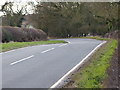
2
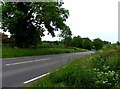
Newton Lane heading towards Newton Harcourt
Image: © Mat Fascione
Taken: 2 Feb 2013
0.14 miles
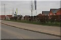
4

Clayhill Field housing estate in Wigston
Image: © Mat Fascione
Taken: 28 Jun 2022
0.15 miles
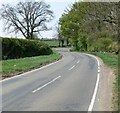
6
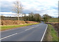
Newton Lane heading towards Wigston
At the entrance to Seven Oaks Farm.
Image: © Mat Fascione
Taken: 2 Feb 2013
0.17 miles
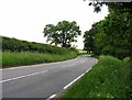
8
New housing estate on Newton Lane, Wigston Magna
Image: © David Howard
Taken: 5 Mar 2023
0.18 miles
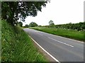
10

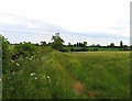
Farmland off Newton Lane near Leicester
Image: © Mat Fascione
Taken: 28 Apr 2007
0.20 miles