IMAGES TAKEN NEAR TO
Brington Close, WIGSTON, LE18 3QR
Introduction
This page details the photographs taken nearby to Brington Close, LE18 3QR by members of the Geograph project.
The Geograph project started in 2005 with the aim of publishing, organising and preserving representative images for every square kilometre of Great Britain, Ireland and the Isle of Man.

There are currently over 7.5m images from over14,400 individuals and you can help contribute to the project by visiting https://www.geograph.org.uk
Image Map
Images are licensed for reuse under creativecommons.org/licenses/by-sa/2.0
Notes
- Clicking on the map will re-center to the selected point.
- The higher the marker number, the further away the image location is from the centre of the postcode.
Image Listing (28 Images Found)
Images are licensed for reuse under creativecommons.org/licenses/by-sa/2.0
Image
Details
Distance
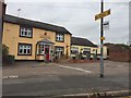
1
Cuisine of India: Kelmarsh Avenue, Wigston
Indian restaurant, previously the 1980s Meadow Bank pub.
Image: © Dylan Moore
Taken: 27 Jun 2016
0.09 miles
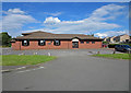
2

The Kings Centre
An evangelical church and community centre opened in 2001 using a redundant hosiery factory.
Image: © Andrew Hill
Taken: 18 Oct 2008
0.14 miles
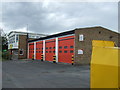
4

Wigston fire station
Wigston fire station, Bull Head Street, Wigston Magna, Leicestershire
Image: © Kevin Hale
Taken: 2 Sep 2007
0.18 miles
5
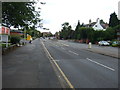
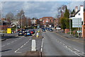
Bull Head Street, Wigston (A5199)
Heading north.
Image: © JThomas
Taken: 9 Aug 2014
0.18 miles
7
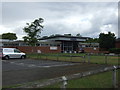
Police Station, Wigston
On Bull Head Street (A5199).
Image: © JThomas
Taken: 9 Aug 2014
0.19 miles
9
Fire Station, Wigston
On Bull Head Street (A5199).
Image: © JThomas
Taken: 9 Aug 2014
0.19 miles
10
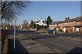
Bull Head Street, Wigston
Looking along the A5199 (formerly the A50) towards Leicester city centre.
Image: © Stephen McKay
Taken: 11 Mar 2012
0.19 miles