IMAGES TAKEN NEAR TO
Weymouth Close, WIGSTON, LE18 2RU
Introduction
This page details the photographs taken nearby to Weymouth Close, LE18 2RU by members of the Geograph project.
The Geograph project started in 2005 with the aim of publishing, organising and preserving representative images for every square kilometre of Great Britain, Ireland and the Isle of Man.

There are currently over 7.5m images from over14,400 individuals and you can help contribute to the project by visiting https://www.geograph.org.uk
Image Map
Images are licensed for reuse under creativecommons.org/licenses/by-sa/2.0
Notes
- Clicking on the map will re-center to the selected point.
- The higher the marker number, the further away the image location is from the centre of the postcode.
Image Listing (21 Images Found)
Images are licensed for reuse under creativecommons.org/licenses/by-sa/2.0
Image
Details
Distance
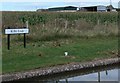
2
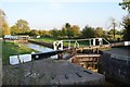
Grand Union Canal - Kilby Bridge Lock
Late afternoon view of the lock.
Image: © Ashley Dace
Taken: Unknown
0.09 miles
4
East end of Durnford Road, Little Hill
Off Horsewell Lane.
Image: © Richard Vince
Taken: 11 Mar 2017
0.13 miles
6
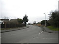
South end of Horsewell Lane, Little Hill
Looking towards Wigston from around the point at which Launceston Road becomes Horsewell Lane.
Image: © Richard Vince
Taken: 11 Mar 2017
0.15 miles
8
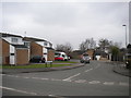
Purbeck Close, Little Hill
Off Horsewell Lane.
Image: © Richard Vince
Taken: 11 Mar 2017
0.18 miles
9
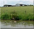
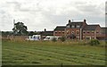
Ivanhoe Farm
Close to the Grand Union Canal near Kilby Bridge.
Image: © Mat Fascione
Taken: 13 Jun 2010
0.18 miles
10
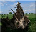
Tree stump near Taylor's Bridge
With Ivanhoe Farm in the background.
Image: © Mat Fascione
Taken: 13 Jun 2010
0.19 miles