IMAGES TAKEN NEAR TO
Buckfast Close, WIGSTON, LE18 2JU
Introduction
This page details the photographs taken nearby to Buckfast Close, LE18 2JU by members of the Geograph project.
The Geograph project started in 2005 with the aim of publishing, organising and preserving representative images for every square kilometre of Great Britain, Ireland and the Isle of Man.

There are currently over 7.5m images from over14,400 individuals and you can help contribute to the project by visiting https://www.geograph.org.uk
Image Map
Images are licensed for reuse under creativecommons.org/licenses/by-sa/2.0
Notes
- Clicking on the map will re-center to the selected point.
- The higher the marker number, the further away the image location is from the centre of the postcode.
Image Listing (10 Images Found)
Images are licensed for reuse under creativecommons.org/licenses/by-sa/2.0
Image
Details
Distance
5
South Leicestershire College
The main entrance into South Leicestershire College, formerly known as Wigston College of Further Education, Station Road, Wigston. October 2008
Image: © Clive Cartwright
Taken: 9 Oct 2008
0.22 miles
6
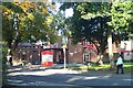
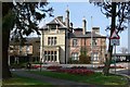
The Manor House, Wigston
The Manor House, Newgate End, looking down onto Gas Lane.
Taken 9th October 2008
Image: © Clive Cartwright
Taken: 9 Oct 2008
0.24 miles
7
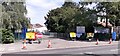
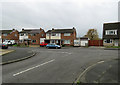
COVID testing centre
COVID test centre.
Image: © Peter Mackenzie
Taken: 8 Jun 2021
0.24 miles
8
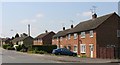
Borough of Oadby & Wigston Council Offices
The main entrance on Station Road in Wigston
Image: © Mat Fascione
Taken: 14 Apr 2007
0.24 miles