IMAGES TAKEN NEAR TO
Pensilva Close, WIGSTON, LE18 2JT
Introduction
This page details the photographs taken nearby to Pensilva Close, LE18 2JT by members of the Geograph project.
The Geograph project started in 2005 with the aim of publishing, organising and preserving representative images for every square kilometre of Great Britain, Ireland and the Isle of Man.

There are currently over 7.5m images from over14,400 individuals and you can help contribute to the project by visiting https://www.geograph.org.uk
Image Map
Images are licensed for reuse under creativecommons.org/licenses/by-sa/2.0
Notes
- Clicking on the map will re-center to the selected point.
- The higher the marker number, the further away the image location is from the centre of the postcode.
Image Listing (15 Images Found)
Images are licensed for reuse under creativecommons.org/licenses/by-sa/2.0
Image
Details
Distance
7
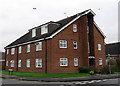
Beth-El Flats on Redruth Avenue
Flats owned by the Bethel Housing Association.
Image: © Andrew Tatlow
Taken: 25 Jan 2016
0.22 miles
10
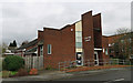
Little Hill Church
An independent Evangelical Church on Launceston Road in Wigston.
Image: © Andrew Tatlow
Taken: 25 Jan 2016
0.24 miles