IMAGES TAKEN NEAR TO
Homestead Drive, WIGSTON, LE18 2HN
Introduction
This page details the photographs taken nearby to Homestead Drive, LE18 2HN by members of the Geograph project.
The Geograph project started in 2005 with the aim of publishing, organising and preserving representative images for every square kilometre of Great Britain, Ireland and the Isle of Man.

There are currently over 7.5m images from over14,400 individuals and you can help contribute to the project by visiting https://www.geograph.org.uk
Image Map
Images are licensed for reuse under creativecommons.org/licenses/by-sa/2.0
Notes
- Clicking on the map will re-center to the selected point.
- The higher the marker number, the further away the image location is from the centre of the postcode.
Image Listing (29 Images Found)
Images are licensed for reuse under creativecommons.org/licenses/by-sa/2.0
Image
Details
Distance
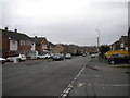
1
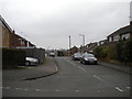
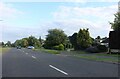
Top of Halcroft Rise, Wigston Magna
Seen from Homestead Drive.
Image: © Richard Vince
Taken: 11 Mar 2017
0.01 miles
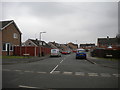
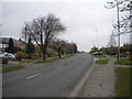
2
Bend in Homestead Drive, Wigston Magna
Image: © Richard Vince
Taken: 11 Mar 2017
0.04 miles
3
South end of Langton Road, Wigston Magna
Seen from Homestead Drive.
Image: © Richard Vince
Taken: 11 Mar 2017
0.05 miles
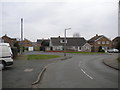
4
Truro Drive, Wigston Magna
Off Horsewell Lane.
Image: © Richard Vince
Taken: 11 Mar 2017
0.10 miles
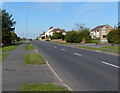
5
Horsewell Lane, Wigston Magna
Looking towards Wigston town centre from the end of Homestead Drive.
Image: © Richard Vince
Taken: 11 Mar 2017
0.10 miles
8
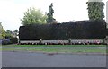
Hedge and floral display on Welford Road, Wigston Magna
Image: © David Howard
Taken: 2 Jul 2023
0.12 miles
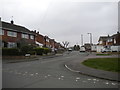
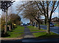
10
Welford Road, Wigston Magna
Looking towards Wigston town centre and Leicester.
Image: © Richard Vince
Taken: 11 Mar 2017
0.13 miles