IMAGES TAKEN NEAR TO
Blunts Lane, WIGSTON, LE18 2HA
Introduction
This page details the photographs taken nearby to Blunts Lane, LE18 2HA by members of the Geograph project.
The Geograph project started in 2005 with the aim of publishing, organising and preserving representative images for every square kilometre of Great Britain, Ireland and the Isle of Man.

There are currently over 7.5m images from over14,400 individuals and you can help contribute to the project by visiting https://www.geograph.org.uk
Image Map
Images are licensed for reuse under creativecommons.org/licenses/by-sa/2.0
Notes
- Clicking on the map will re-center to the selected point.
- The higher the marker number, the further away the image location is from the centre of the postcode.
Image Listing (74 Images Found)
Images are licensed for reuse under creativecommons.org/licenses/by-sa/2.0
Image
Details
Distance
1
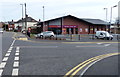
Sainsbury's Local convenience store
On Moat Street in Wigston.
Image: © Mat Fascione
Taken: 12 Apr 2015
0.06 miles
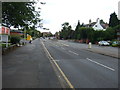
2
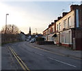
Terraced housing on Moat Street in Wigston
In the distance is All Saints Church.
Image: © Mat Fascione
Taken: 16 Feb 2014
0.07 miles

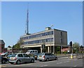
5
Police Station, Wigston
On Bull Head Street (A5199).
Image: © JThomas
Taken: 9 Aug 2014
0.09 miles
6
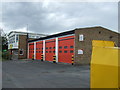
Fire Station, Wigston
On Bull Head Street (A5199).
Image: © JThomas
Taken: 9 Aug 2014
0.10 miles
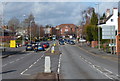
9
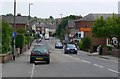
Bull Head Street, Wigston (A5199)
Heading north.
Image: © JThomas
Taken: 9 Aug 2014
0.11 miles
10
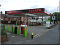
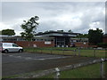
Service station on Bull Head Street, Wigston
Image: © JThomas
Taken: 9 Aug 2014
0.11 miles