IMAGES TAKEN NEAR TO
Moat Street, WIGSTON, LE18 2GD
Introduction
This page details the photographs taken nearby to Moat Street, LE18 2GD by members of the Geograph project.
The Geograph project started in 2005 with the aim of publishing, organising and preserving representative images for every square kilometre of Great Britain, Ireland and the Isle of Man.

There are currently over 7.5m images from over14,400 individuals and you can help contribute to the project by visiting https://www.geograph.org.uk
Image Map
Images are licensed for reuse under creativecommons.org/licenses/by-sa/2.0
Notes
- Clicking on the map will re-center to the selected point.
- The higher the marker number, the further away the image location is from the centre of the postcode.
Image Listing (72 Images Found)
Images are licensed for reuse under creativecommons.org/licenses/by-sa/2.0
Image
Details
Distance

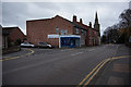
3
Site of a former hospital
On Blunt's Lane, now a site of nine bungalows. http://www.geograph.org.uk/photo/4785197
Image: © Ian S
Taken: 6 Dec 2015
0.08 miles
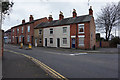
4
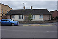
Bungalows on Blunt's Lane
Site of a former hospital built in 1781. http://www.geograph.org.uk/photo/4785202
Image: © Ian S
Taken: 6 Dec 2015
0.08 miles
5
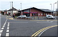
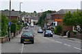
Sainsbury's Local convenience store
On Moat Street in Wigston.
Image: © Mat Fascione
Taken: 12 Apr 2015
0.09 miles
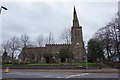
9
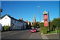
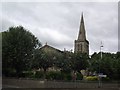
All Saint's Church, Wigston
View looking up Moat Street, to Bushloe End, Wigston Magna.
Taken 9th October 2008
Image: © Clive Cartwright
Taken: 9 Oct 2008
0.09 miles