IMAGES TAKEN NEAR TO
Viking Road, WIGSTON, LE18 2BL
Introduction
This page details the photographs taken nearby to Viking Road, LE18 2BL by members of the Geograph project.
The Geograph project started in 2005 with the aim of publishing, organising and preserving representative images for every square kilometre of Great Britain, Ireland and the Isle of Man.

There are currently over 7.5m images from over14,400 individuals and you can help contribute to the project by visiting https://www.geograph.org.uk
Image Map
Images are licensed for reuse under creativecommons.org/licenses/by-sa/2.0
Notes
- Clicking on the map will re-center to the selected point.
- The higher the marker number, the further away the image location is from the centre of the postcode.
Image Listing (18 Images Found)
Images are licensed for reuse under creativecommons.org/licenses/by-sa/2.0
Image
Details
Distance
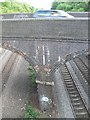
1
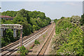
Mainline railway
Looking due north towards Leicester from the Image The bridge in the distance, carrying the A563 over the track, is in Image
Image: © Kate Jewell
Taken: 2 Jun 2006
0.08 miles
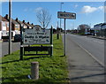
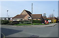
2
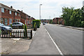
West Avenue, Wigston, Leicester
1960s - 1970s residential development on the left, Chartwell Drive Industrial Estate on the right.
Image: © Kate Jewell
Taken: 2 Jun 2006
0.08 miles

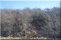
8
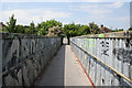
Footbridge over the railway on Aylestone Lane
Image: © Kate Jewell
Taken: 2 Jun 2006
0.15 miles
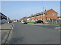
9
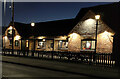
The Chartwell Arms
A public house on the corner of Chartwell Drive and West Avenue in Wigston.
Image: © Mat Fascione
Taken: 5 Jan 2022
0.17 miles
10
The Chartwell Arms pub, Wigston
On West Avenue.
Image: © JThomas
Taken: 29 Mar 2014
0.17 miles