IMAGES TAKEN NEAR TO
Central Avenue, WIGSTON, LE18 2AA
Introduction
This page details the photographs taken nearby to Central Avenue, LE18 2AA by members of the Geograph project.
The Geograph project started in 2005 with the aim of publishing, organising and preserving representative images for every square kilometre of Great Britain, Ireland and the Isle of Man.

There are currently over 7.5m images from over14,400 individuals and you can help contribute to the project by visiting https://www.geograph.org.uk
Image Map
Images are licensed for reuse under creativecommons.org/licenses/by-sa/2.0
Notes
- Clicking on the map will re-center to the selected point.
- The higher the marker number, the further away the image location is from the centre of the postcode.
Image Listing (66 Images Found)
Images are licensed for reuse under creativecommons.org/licenses/by-sa/2.0
Image
Details
Distance
1
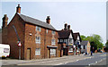
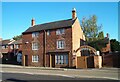
Wigston Framework Knitters' Museum, Bushloe End
Image: © Alex Cameron
Taken: 12 May 2006
0.04 miles
2
The Framework Knitters Museum
On Bushloe End, Wigston
Image: © Ian S
Taken: 6 Dec 2015
0.07 miles
5
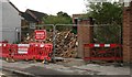
Demolished building on Long Street, Wigston
Image: © Mat Fascione
Taken: 19 May 2017
0.08 miles
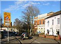
6
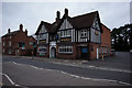
The Plough public house
On Bushloe End, Wigston. http://www.geograph.org.uk/photo/4785999
Image: © Ian S
Taken: 6 Dec 2015
0.08 miles
7
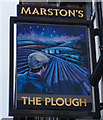
The Plough public house
On Bushloe End, Wigston. http://www.geograph.org.uk/photo/4785994
Image: © Ian S
Taken: 6 Dec 2015
0.08 miles
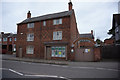
8
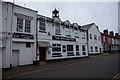
The Winchester Snooker Club
On Central Avenue, Wigston.
Image: © Ian S
Taken: 6 Dec 2015
0.08 miles
9
The Framework Knitters Museum
The Framework knitters museum, Bushloe End, Wigston Magna. October 2008
Image: © Clive Cartwright
Taken: 9 Oct 2008
0.08 miles
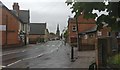
10
Wigston United Reformed Church
On Long Street in Wigston.
Image: © Mat Fascione
Taken: 20 Mar 2017
0.09 miles