IMAGES TAKEN NEAR TO
Grange Road, WIGSTON, LE18 1JG
Introduction
This page details the photographs taken nearby to Grange Road, LE18 1JG by members of the Geograph project.
The Geograph project started in 2005 with the aim of publishing, organising and preserving representative images for every square kilometre of Great Britain, Ireland and the Isle of Man.

There are currently over 7.5m images from over14,400 individuals and you can help contribute to the project by visiting https://www.geograph.org.uk
Image Map
Images are licensed for reuse under creativecommons.org/licenses/by-sa/2.0
Notes
- Clicking on the map will re-center to the selected point.
- The higher the marker number, the further away the image location is from the centre of the postcode.
Image Listing (27 Images Found)
Images are licensed for reuse under creativecommons.org/licenses/by-sa/2.0
Image
Details
Distance
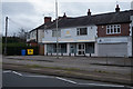
2
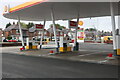
Shell petrol station on Leicester Road, Wigston
Image: © David Howard
Taken: 5 Jun 2022
0.09 miles
4
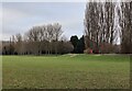
Playing fields at Knighton Park
Next to Brighton Avenue in Wigston.
Image: © Mat Fascione
Taken: 21 Feb 2023
0.10 miles
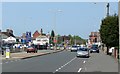
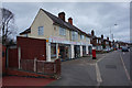
7
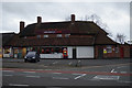
Former public house on Leicester Road
Now a Sainsbury's Local.
Image: © Ian S
Taken: 6 Dec 2015
0.11 miles
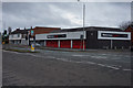
8
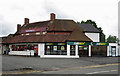
Convenience store: Leicester Road, Wigston
This was previously the Royal Oak pub.
Image: © Dylan Moore
Taken: 27 Jun 2016
0.11 miles