IMAGES TAKEN NEAR TO
Croft Drive, WIGSTON, LE18 1HE
Introduction
This page details the photographs taken nearby to Croft Drive, LE18 1HE by members of the Geograph project.
The Geograph project started in 2005 with the aim of publishing, organising and preserving representative images for every square kilometre of Great Britain, Ireland and the Isle of Man.

There are currently over 7.5m images from over14,400 individuals and you can help contribute to the project by visiting https://www.geograph.org.uk
Image Map
Images are licensed for reuse under creativecommons.org/licenses/by-sa/2.0
Notes
- Clicking on the map will re-center to the selected point.
- The higher the marker number, the further away the image location is from the centre of the postcode.
Image Listing (18 Images Found)
Images are licensed for reuse under creativecommons.org/licenses/by-sa/2.0
Image
Details
Distance
3
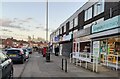
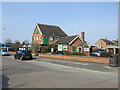
Shops on Shackerdale Road in West Knighton, Leicester
Image: © Mat Fascione
Taken: 22 Feb 2022
0.20 miles
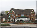
4
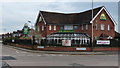
The Aberdale
Everards public house on the corner of Asquith Boulevard and Shackerdale Road.
Image: © Mat Fascione
Taken: 12 Mar 2017
0.20 miles
6
Leicester (Knighton) Aberdale
111 Shackerdale Road. Everards suburban pub.
Image: © the bitterman
Taken: 15 Apr 2010
0.21 miles
7

Northbound freight on the Midland main line
Image: © Tim Glover
Taken: 27 Jul 2016
0.22 miles
8
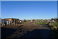
Aylestone Lane Allotments
162 plots owned and administered by Oadby & Wigston Council
Image: © Tim Heaton
Taken: 17 Jan 2022
0.22 miles
10
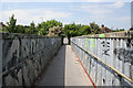
Footbridge over the railway on Aylestone Lane
Image: © Kate Jewell
Taken: 2 Jun 2006
0.23 miles