IMAGES TAKEN NEAR TO
Aylestone Lane, WIGSTON, LE18 1BD
Introduction
This page details the photographs taken nearby to Aylestone Lane, LE18 1BD by members of the Geograph project.
The Geograph project started in 2005 with the aim of publishing, organising and preserving representative images for every square kilometre of Great Britain, Ireland and the Isle of Man.

There are currently over 7.5m images from over14,400 individuals and you can help contribute to the project by visiting https://www.geograph.org.uk
Image Map
Images are licensed for reuse under creativecommons.org/licenses/by-sa/2.0
Notes
- Clicking on the map will re-center to the selected point.
- The higher the marker number, the further away the image location is from the centre of the postcode.
Image Listing (14 Images Found)
Images are licensed for reuse under creativecommons.org/licenses/by-sa/2.0
Image
Details
Distance
1
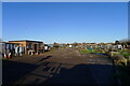
Aylestone Lane Allotments
162 plots owned and administered by Oadby & Wigston Council
Image: © Tim Heaton
Taken: 17 Jan 2022
0.07 miles
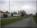
2
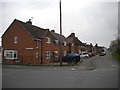
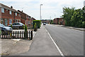
Houses on Aylestone Lane, Wigston Fields
Accessed via a service road off Rolleston Road.
Image: © Richard Vince
Taken: 11 Mar 2017
0.10 miles
4
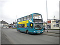
Bus on Rolleston Road, Wigston Fields
Arriva Midlands 4204, a Volvo B9TL/Wright Eclipse Gemini, waits for time outside the Nautical William pub while working route 49A from South Wigston to Leicester city centre.
Image: © Richard Vince
Taken: 11 Mar 2017
0.12 miles
5
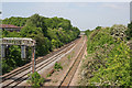
Mainline railway
Looking due north towards Leicester from the Image The bridge in the distance, carrying the A563 over the track, is in Image
Image: © Kate Jewell
Taken: 2 Jun 2006
0.13 miles
6
West Avenue, Wigston, Leicester
1960s - 1970s residential development on the left, Chartwell Drive Industrial Estate on the right.
Image: © Kate Jewell
Taken: 2 Jun 2006
0.13 miles
7
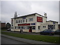
The Nautical William, Aylestone Lane, Wigston Fields
An apparently well presented pub, which at least partly makes up for its singularly uninspiring architecture.
Image: © Richard Vince
Taken: 11 Mar 2017
0.13 miles
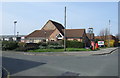
8
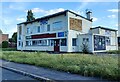
Former Nautical William Pub
This former pub got its name when the King William IV pub in Bell Street Wigston was demolished after the Second World War, the licence was transferred to the new Nautical William in Aylestone Lane when the surrounding estate was built. It probably dates to the late 1950s. It has now closed and will probably be demolished and replaced with a block of flats.
Image: © Mat Fascione
Taken: 5 Jul 2022
0.13 miles
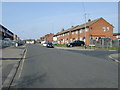
9
Aylestone Lane, Wigston Fields
Complete with service road (foreground).
Image: © Richard Vince
Taken: 11 Mar 2017
0.13 miles
10
The Chartwell Arms pub, Wigston
On West Avenue.
Image: © JThomas
Taken: 29 Mar 2014
0.17 miles