IMAGES TAKEN NEAR TO
Trolley Close, LUTTERWORTH, LE17 6RF
Introduction
This page details the photographs taken nearby to Trolley Close, LE17 6RF by members of the Geograph project.
The Geograph project started in 2005 with the aim of publishing, organising and preserving representative images for every square kilometre of Great Britain, Ireland and the Isle of Man.

There are currently over 7.5m images from over14,400 individuals and you can help contribute to the project by visiting https://www.geograph.org.uk
Image Map
Images are licensed for reuse under creativecommons.org/licenses/by-sa/2.0
Notes
- Clicking on the map will re-center to the selected point.
- The higher the marker number, the further away the image location is from the centre of the postcode.
Image Listing (28 Images Found)
Images are licensed for reuse under creativecommons.org/licenses/by-sa/2.0
Image
Details
Distance
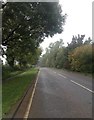
1
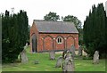
Welford Road cemetery
To the south of the village of Husbands Bosworth. The cemetery was established in 1858.
Image: © Mat Fascione
Taken: 2 Sep 2007
0.04 miles
2

Welford Road Cemetery and Chapel of Rest
On a very frosty December afternoon
Image: © Graham Hogg
Taken: 7 Dec 2010
0.05 miles
5
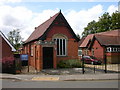
Husbands Bosworth Methodist Church
On Welford Road.
Image: © Ian Rob
Taken: 31 Jul 2009
0.13 miles
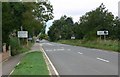
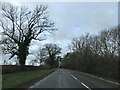
6

A4304, Kilworth Road, approaching Husbands Bosworth
Image: © David Dixon
Taken: 1 Jun 2024
0.14 miles
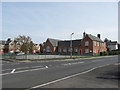
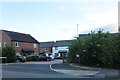
10
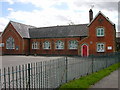
Husbands Bosworth School
Looking from Welford Road.
Image: © Ian Rob
Taken: 31 Jul 2009
0.17 miles