IMAGES TAKEN NEAR TO
Chapel Lane, LUTTERWORTH, LE17 6NX
Introduction
This page details the photographs taken nearby to Chapel Lane, LE17 6NX by members of the Geograph project.
The Geograph project started in 2005 with the aim of publishing, organising and preserving representative images for every square kilometre of Great Britain, Ireland and the Isle of Man.

There are currently over 7.5m images from over14,400 individuals and you can help contribute to the project by visiting https://www.geograph.org.uk
Image Map
Images are licensed for reuse under creativecommons.org/licenses/by-sa/2.0
Notes
- Clicking on the map will re-center to the selected point.
- The higher the marker number, the further away the image location is from the centre of the postcode.
Image Listing (15 Images Found)
Images are licensed for reuse under creativecommons.org/licenses/by-sa/2.0
Image
Details
Distance
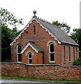
1
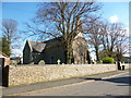
Mowsley Church
Saint Nicholas on Main Street.
Image: © Ian Rob
Taken: 11 Apr 2014
0.04 miles
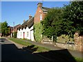
3
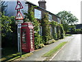
Mowsley
Cottages at the northern end of the village.
Image: © Stephen McKay
Taken: 15 Jul 2006
0.05 miles
5
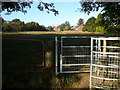
Footpath and kissing gate east of Mowsley Church
Image: © Colin Park
Taken: 27 Sep 2009
0.08 miles
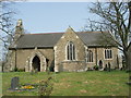
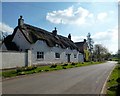
6
Mowsley
Looking along Main Street towards the church.
Image: © Stephen McKay
Taken: 15 Jul 2006
0.10 miles
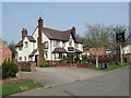
10
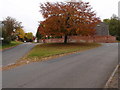
Road junction and grass triangle
Road junction in Mowsley with a well maintained grass traffic splitter. The yellowish sign on the farm building is the Atcost logo. A popular choice for farmers and industry since the 1950's and still going.
Image: © Michael Trolove
Taken: 29 Oct 2016
0.18 miles