IMAGES TAKEN NEAR TO
Theddingworth, LUTTERWORTH, LE17 6NJ
Introduction
This page details the photographs taken nearby to LE17 6NJ by members of the Geograph project.
The Geograph project started in 2005 with the aim of publishing, organising and preserving representative images for every square kilometre of Great Britain, Ireland and the Isle of Man.

There are currently over 7.5m images from over14,400 individuals and you can help contribute to the project by visiting https://www.geograph.org.uk
Image Map
Images are licensed for reuse under creativecommons.org/licenses/by-sa/2.0
Notes
- Clicking on the map will re-center to the selected point.
- The higher the marker number, the further away the image location is from the centre of the postcode.
Image Listing (9 Images Found)
Images are licensed for reuse under creativecommons.org/licenses/by-sa/2.0
Image
Details
Distance
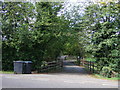
2
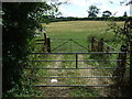
Gated field entrance off Theddingworth Road (A304)
Image: © JThomas
Taken: 9 Aug 2014
0.08 miles
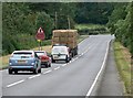
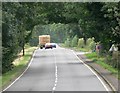
3
A4304 between Husbands Bosworth and Theddingworth
Image: © David Dixon
Taken: 1 Jun 2024
0.09 miles
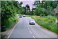
5
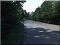
Theddingworth Road (A304)
Heading south west towards Lutterworth.
Image: © JThomas
Taken: 9 Aug 2014
0.11 miles
6
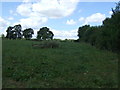
Grazing near Dene Lodge
Off Theddingworth Road (A304).
Image: © JThomas
Taken: 9 Aug 2014
0.15 miles
8
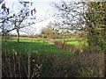
Fields
View to the north from Theddingworth Road
Image: © Andrew Tatlow
Taken: 29 Nov 2006
0.20 miles