IMAGES TAKEN NEAR TO
Lammas Close, LUTTERWORTH, LE17 6LL
Introduction
This page details the photographs taken nearby to Lammas Close, LE17 6LL by members of the Geograph project.
The Geograph project started in 2005 with the aim of publishing, organising and preserving representative images for every square kilometre of Great Britain, Ireland and the Isle of Man.

There are currently over 7.5m images from over14,400 individuals and you can help contribute to the project by visiting https://www.geograph.org.uk
Image Map
Images are licensed for reuse under creativecommons.org/licenses/by-sa/2.0
Notes
- Clicking on the map will re-center to the selected point.
- The higher the marker number, the further away the image location is from the centre of the postcode.
Image Listing (57 Images Found)
Images are licensed for reuse under creativecommons.org/licenses/by-sa/2.0
Image
Details
Distance
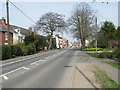
1
Husbands Bosworth Butt Lane
At the junction with High Street.
Image: © Ian Rob
Taken: 31 Jul 2009
0.08 miles
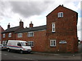
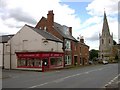
3
Husbands Bosworth High Street
House on High Street which was once the Graziers Arms, still has the brewery's sign on the wall.
Image: © Ian Rob
Taken: 31 Jul 2009
0.08 miles
4
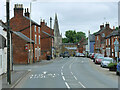
The High Street, Husbands Bosworth
Looking along Berridges Lane to its junction with High Street. For detailed information about the village: http://www.british-history.ac.uk/report.asp?compid=22039&strquery=husbands%20bosworth#s1
Image: © Mat Fascione
Taken: 2 Sep 2007
0.09 miles
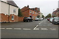
6
Husbands Bosworth High Street
Estate Agents on the corner of Mowsley Road.
Image: © Ian Rob
Taken: 31 Jul 2009
0.09 miles
7
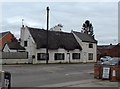
Thatched Cottage - Husbands Bosworth
Image: © Anthony Parkes
Taken: 29 Apr 2017
0.10 miles
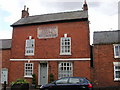
8
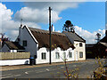
Hunters Cottage, Husbands Bosworth
This cottage on High Street is looking very smart after being re-thatched in 2020. The building was at one time a general store and fishing tackle shop. After the Second World War the thatched roof was covered with asbestos sheeting which was replaced by traditional thatch in 1979.
Image: © Stephen McKay
Taken: 29 Apr 2021
0.10 miles
9
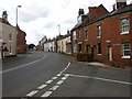
Husbands Bosworth High Street
Husbands Bosworth is a large crossroads village in South Leicestershire. It is situated on the intersection of the A5199 (formerly the A50 Trunk Road), Leicester to Northampton road, and the A4304 (formerly the A427 Trunk Road), Lutterworth to Market Harborough road. With three churches, a school, a "small stately home", and other buildings of interest Husbands Bosworth, may be considered to be a "typical" English village.
Image: © David Dixon
Taken: 1 Jun 2024
0.10 miles
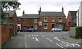
10
Husbands Bosworth High Street
Looking south westerly from the Church.
Image: © Ian Rob
Taken: 31 Jul 2009
0.10 miles