IMAGES TAKEN NEAR TO
Lilbourne Lane, LUTTERWORTH, LE17 6EH
Introduction
This page details the photographs taken nearby to Lilbourne Lane, LE17 6EH by members of the Geograph project.
The Geograph project started in 2005 with the aim of publishing, organising and preserving representative images for every square kilometre of Great Britain, Ireland and the Isle of Man.

There are currently over 7.5m images from over14,400 individuals and you can help contribute to the project by visiting https://www.geograph.org.uk
Image Map
Images are licensed for reuse under creativecommons.org/licenses/by-sa/2.0
Notes
- Clicking on the map will re-center to the selected point.
- The higher the marker number, the further away the image location is from the centre of the postcode.
Image Listing (31 Images Found)
Images are licensed for reuse under creativecommons.org/licenses/by-sa/2.0
Image
Details
Distance
1
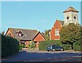
Catthorpe, Leicestershire
New housing along Lilbourne Lane, the clock tower looks a lot older.
Image: © Mat Fascione
Taken: 20 Oct 2007
0.03 miles
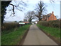
2
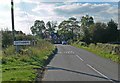
Main Street, Catthorpe
This was once the main road between Rugby and Market Harborough; it has now been declassified with signposting firmly discouraging long-distance traffic, leaving Catthorpe as a sleepy backwater. The lane to the right leads to Lilbourne past the site of the long-closed Lilbourne station.
Image: © Stephen McKay
Taken: 12 Jan 2008
0.04 miles
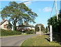
3
Entering Catthorpe
Heading west on Station Road.
Image: © JThomas
Taken: 29 Mar 2014
0.04 miles
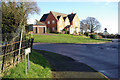
4
Swinford Road in Catthorpe
This is the most southerly village in Leicestershire.
Image: © Mat Fascione
Taken: 20 Oct 2007
0.05 miles
5

Christmas Lights in Catthorpe
This house is always one for having as many lights as possible!
Image: © Jony Haworth
Taken: 26 Dec 2005
0.06 miles
6
Approaching Catthorpe along Swinford Road
This is the most southerly village in Leicestershire.
Image: © Mat Fascione
Taken: 20 Oct 2007
0.07 miles
7
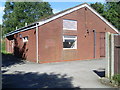
Telephone Exchange, Catthorpe
Situated in Lilbourne Road, this redbrick TE, taken in bright sunlight, used to take the name Swinford TE, which might have meant that the former TE was in that village. This modern TE now provides telephone and broadband services to Catthorpe, Clay Coton, Lilbourne, Shawell, Stanford on Avon, Swinford and the surrounding rural area. The numbering range of this TE is (01788) 860xxx, 869xxx, the (01788) referring to the Rugby group of TEs, and its postcode is LE17 6DE.
Image: © David Hillas
Taken: 2 Sep 2013
0.08 miles

10

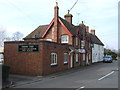
The Cherry Tree
Public house in Catthorpe.
Image: © Trevor Harris
Taken: 18 May 2018
0.08 miles