IMAGES TAKEN NEAR TO
Walcote Road, LUTTERWORTH, LE17 6EE
Introduction
This page details the photographs taken nearby to Walcote Road, LE17 6EE by members of the Geograph project.
The Geograph project started in 2005 with the aim of publishing, organising and preserving representative images for every square kilometre of Great Britain, Ireland and the Isle of Man.

There are currently over 7.5m images from over14,400 individuals and you can help contribute to the project by visiting https://www.geograph.org.uk
Image Map
Images are licensed for reuse under creativecommons.org/licenses/by-sa/2.0
Notes
- Clicking on the map will re-center to the selected point.
- The higher the marker number, the further away the image location is from the centre of the postcode.
Image Listing (59 Images Found)
Images are licensed for reuse under creativecommons.org/licenses/by-sa/2.0
Image
Details
Distance
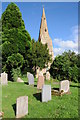
1
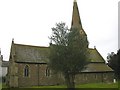
South Kilworth
Church of St Nicholas, a well looked after Church in centre of village.
Image: © Ian Rob
Taken: 11 Apr 2006
0.03 miles
2
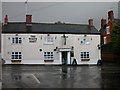
South Kilworth-The White Hart
On Rugby Road.
Image: © Ian Rob
Taken: 23 Oct 2010
0.03 miles
3
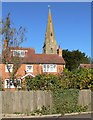
St Nicholas Church, South Kilworth
The houses are along Walcote road.
Image: © Mat Fascione
Taken: 20 Oct 2007
0.03 miles
4
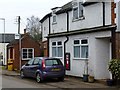
South Kilworth Old Post Office and Bus Shelter
On Walcote Road.
Image: © Ian Rob
Taken: 12 Feb 2015
0.03 miles
5
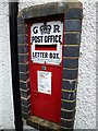
South Kilworth Post Box
Set in the wall of the old Post Office.
Image: © Ian Rob
Taken: 12 Feb 2015
0.03 miles
6
South Kilworth church
South Kilworth church is dedicated to St Nicholas.
Image: © Philip Halling
Taken: 15 Aug 2013
0.04 miles
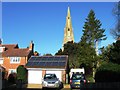
7
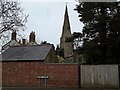
South Kilworth-Rugby Road
A view of Saint Nicholas Church Spire.
Image: © Ian Rob
Taken: 12 Feb 2015
0.04 miles
9

St Nicholas, South Kilworth - Path to porch
Image: © John Salmon
Taken: 13 Apr 2013
0.04 miles
