IMAGES TAKEN NEAR TO
Welford Road, LUTTERWORTH, LE17 6EA
Introduction
This page details the photographs taken nearby to Welford Road, LE17 6EA by members of the Geograph project.
The Geograph project started in 2005 with the aim of publishing, organising and preserving representative images for every square kilometre of Great Britain, Ireland and the Isle of Man.

There are currently over 7.5m images from over14,400 individuals and you can help contribute to the project by visiting https://www.geograph.org.uk
Image Map
Images are licensed for reuse under creativecommons.org/licenses/by-sa/2.0
Notes
- Clicking on the map will re-center to the selected point.
- The higher the marker number, the further away the image location is from the centre of the postcode.
Image Listing (24 Images Found)
Images are licensed for reuse under creativecommons.org/licenses/by-sa/2.0
Image
Details
Distance
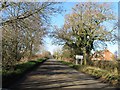
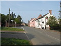
1
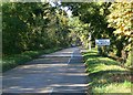
Approaching South Kilworth
North west along Welford Road.
Image: © Mat Fascione
Taken: 20 Oct 2007
0.09 miles
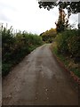
8
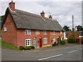
South Kilworth Cottages
On the corner of Welford Road and North Road.
Image: © Ian Rob
Taken: 31 Jul 2009
0.20 miles
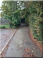
10
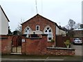
South Kilworth Old Chapel
Dating from the 19th century, converted to a private house.
Image: © Ian Rob
Taken: 12 Feb 2015
0.21 miles