IMAGES TAKEN NEAR TO
Main Street, LUTTERWORTH, LE17 6AG
Introduction
This page details the photographs taken nearby to Main Street, LE17 6AG by members of the Geograph project.
The Geograph project started in 2005 with the aim of publishing, organising and preserving representative images for every square kilometre of Great Britain, Ireland and the Isle of Man.

There are currently over 7.5m images from over14,400 individuals and you can help contribute to the project by visiting https://www.geograph.org.uk
Image Map
Images are licensed for reuse under creativecommons.org/licenses/by-sa/2.0
Notes
- Clicking on the map will re-center to the selected point.
- The higher the marker number, the further away the image location is from the centre of the postcode.
Image Listing (45 Images Found)
Images are licensed for reuse under creativecommons.org/licenses/by-sa/2.0
Image
Details
Distance
1
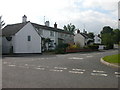
White Swan, Shawell
Lovely pub for lunchtime and evening meals - recommend it - good car park, if a tad hilly :)
Image: © Michael Westley
Taken: 6 Apr 2010
0.02 miles
2
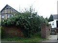
Partly hidden footpath, Shawell Main Street
Partly obscured by overgrowth, a narrow footpath leads up to end of gardens then left along route of Great Central Railway until reaching junction with other paths at south of village
Image: © Michael Westley
Taken: 6 Apr 2010
0.04 miles
3
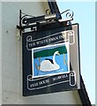
The White Swan Inn, Shawell
A close up of the pub sign, on Main Street in the Leicestershire village of Shawell.
Image: © Mat Fascione
Taken: 20 Oct 2007
0.04 miles
4
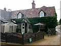
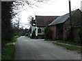
Shawell-The White Swan
Public House on Main Street.
Image: © Ian Rob
Taken: 23 Oct 2010
0.05 miles
5
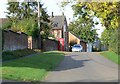
The Main Street in Shawell, Leicestershire
Image: © Mat Fascione
Taken: 20 Oct 2007
0.09 miles
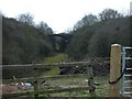
6
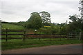
Gibbet Lane, Shawell
View north from lane between Shawell and A5/A426, showing new gate on right for ROW / FP that runs north beside gravel workings, along route of Great Central Railway line (trees in middle of picture). For railway buffs, this location was originally a bridge (now filled in).
Image: © Michael Westley
Taken: 27 May 2009
0.09 miles
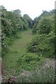
7
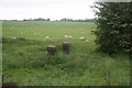
Great Central Railway, Shawell
From Gibbet Lane, close to FP that runs north, what appears to be last reminder of railway is in grass. Looks like brick posts that may have led down to railway line (now filled in). Subsequent to taking this photo, the landowner appears to have dismantled these, and a pile of bricks remains. Ay well.
In the background, sheep are grazing on grounds near sand/gravel pits.
Image: © Michael Westley
Taken: 27 May 2009
0.09 miles
8
Great Central Railway, Shawell
Looking south from Gibbet Lane, old trackbed of Great Central Railway line, and bridge (no 434) in distance. The route under the road is filled in.
Image: © Michael Westley
Taken: 27 May 2009
0.09 miles
9
Great Central Railway bridge, Shawell
On private land, one of many bridges remains intact, west of Shawell village, south of Gibbet Lane
Image: © Michael Westley
Taken: 6 Apr 2010
0.09 miles