IMAGES TAKEN NEAR TO
Lutterworth Road, LUTTERWORTH, LE17 5RZ
Introduction
This page details the photographs taken nearby to Lutterworth Road, LE17 5RZ by members of the Geograph project.
The Geograph project started in 2005 with the aim of publishing, organising and preserving representative images for every square kilometre of Great Britain, Ireland and the Isle of Man.

There are currently over 7.5m images from over14,400 individuals and you can help contribute to the project by visiting https://www.geograph.org.uk
Image Map
Images are licensed for reuse under creativecommons.org/licenses/by-sa/2.0
Notes
- Clicking on the map will re-center to the selected point.
- The higher the marker number, the further away the image location is from the centre of the postcode.
Image Listing (10 Images Found)
Images are licensed for reuse under creativecommons.org/licenses/by-sa/2.0
Image
Details
Distance
3
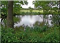
Small pond west of Kimcote in Leicestershire
On the northern side of Lutterworth Road.
Image: © Mat Fascione
Taken: 22 Jun 2008
0.11 miles
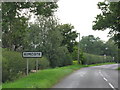
5
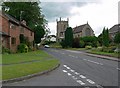
All Saints Church in Kimcote, Leicestershire
Looking west along Walton Road from the junction of Poultney Lane.
Image: © Mat Fascione
Taken: 22 Jun 2008
0.22 miles
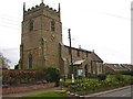
6
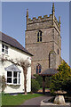
Kimcote Church
All Saints' Church towers over Church Cottage on Walton Road in Kimcote. The church, which also serves the neighbouring village of Walton, dates from the 13th century although some features may be older. It originally had a steeple above the tower but this fell into the church in 1771 and the tower was rebuilt without one. Note the 20th century clockface on the south elevation of the tower. The church was restored in 1869 by William Smith and is now grade II listed.
Image: © Stephen McKay
Taken: 31 Mar 2021
0.22 miles
7
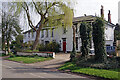
The Old Rectory and the White House, Kimcote
The Old Rectory dates from mid 18th century; however, the three bayed section to the right was an 1834 extension, now known as the White House. Both are grade II listed.
Image: © Stephen McKay
Taken: 31 Mar 2021
0.22 miles
8
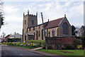
Kimcote Church
All Saints' Church stands in a prominent position on Walton Road in the centre of the village. It is of 13th century origin (although some features may be older) and, in common with many English churches, was restored in Victorian times.
Image: © Stephen McKay
Taken: 31 Mar 2021
0.23 miles
9

Kimcote Churchyard
The churchyard belonging to All Saints' Church is kept immaculately.
Image: © Stephen McKay
Taken: 31 Mar 2021
0.24 miles
10
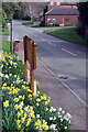
Walton Road, Kimcote
The daffodils make a fine sight on the bank below All Saints' church on an unusually warm afternoon in late March. The footpath leading off to the left heads towards Walton. Further along Poultney Lane leads off to the right.
Image: © Stephen McKay
Taken: 31 Mar 2021
0.25 miles