IMAGES TAKEN NEAR TO
Bruntingthorpe, LUTTERWORTH, LE17 5QL
Introduction
This page details the photographs taken nearby to LE17 5QL by members of the Geograph project.
The Geograph project started in 2005 with the aim of publishing, organising and preserving representative images for every square kilometre of Great Britain, Ireland and the Isle of Man.

There are currently over 7.5m images from over14,400 individuals and you can help contribute to the project by visiting https://www.geograph.org.uk
Image Map
Images are licensed for reuse under creativecommons.org/licenses/by-sa/2.0
Notes
- Clicking on the map will re-center to the selected point.
- The higher the marker number, the further away the image location is from the centre of the postcode.
Image Listing (17 Images Found)
Images are licensed for reuse under creativecommons.org/licenses/by-sa/2.0
Image
Details
Distance
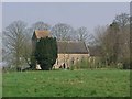
1
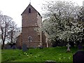
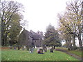
Bruntingthorpe
St Mary's Church at the end of a narrow lane.
Image: © Ian Rob
Taken: 2 May 2006
0.04 miles
4
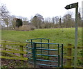
Bruntingthorpe
Looking along road towards Peatling Parva, perimeter fence of Bruntingthorpe aerodrome is on left of picture.
Image: © Ian Rob
Taken: 2 May 2006
0.09 miles
7
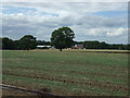
Farmland west of Bruntingthorpe
Off Bruntingthorpe Road.
Image: © JThomas
Taken: 9 Aug 2014
0.15 miles
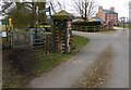
8
Bruntingthorpe Joiners Arms
Church Walk. Gastropub.
Image: © the bitterman
Taken: 4 Jun 2012
0.17 miles
9
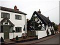
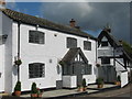
Bruntingthorpe
Joiner's Arms Public House and neighbouring Thatched Cottage.
Image: © Ian Rob
Taken: 2 May 2006
0.17 miles
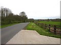
10
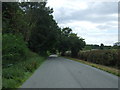
Bruntingthorpe Road
Heading south west toward Peatling Parva.
Image: © JThomas
Taken: 9 Aug 2014
0.21 miles