IMAGES TAKEN NEAR TO
Ullesthorpe Road, LUTTERWORTH, LE17 5PD
Introduction
This page details the photographs taken nearby to Ullesthorpe Road, LE17 5PD by members of the Geograph project.
The Geograph project started in 2005 with the aim of publishing, organising and preserving representative images for every square kilometre of Great Britain, Ireland and the Isle of Man.

There are currently over 7.5m images from over14,400 individuals and you can help contribute to the project by visiting https://www.geograph.org.uk
Image Map
Images are licensed for reuse under creativecommons.org/licenses/by-sa/2.0
Notes
- Clicking on the map will re-center to the selected point.
- The higher the marker number, the further away the image location is from the centre of the postcode.
Image Listing (5 Images Found)
Images are licensed for reuse under creativecommons.org/licenses/by-sa/2.0
Image
Details
Distance
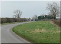
1
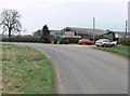
High Ridge Farm
On a bend in Ullesthorpe Road near Gilmorton in Leicestershire.
Image: © Mat Fascione
Taken: 24 Feb 2008
0.02 miles
2
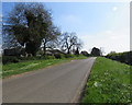
Ullesthorpe Road passes High Ridge Farm
Image: © Andrew Tatlow
Taken: 10 May 2017
0.02 miles
3
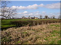
Gilmorton
East of High Ridge Farm on road to Gilmorton
Image: © Ian Rob
Taken: 4 Apr 2006
0.06 miles
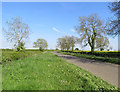
5
Ullesthorpe Road in Leicestershire
Looking towards High Ridge Farm.
Image: © Mat Fascione
Taken: 24 Feb 2008
0.17 miles