IMAGES TAKEN NEAR TO
Ashby Road, LUTTERWORTH, LE17 5LY
Introduction
This page details the photographs taken nearby to Ashby Road, LE17 5LY by members of the Geograph project.
The Geograph project started in 2005 with the aim of publishing, organising and preserving representative images for every square kilometre of Great Britain, Ireland and the Isle of Man.

There are currently over 7.5m images from over14,400 individuals and you can help contribute to the project by visiting https://www.geograph.org.uk
Image Map
Images are licensed for reuse under creativecommons.org/licenses/by-sa/2.0
Notes
- Clicking on the map will re-center to the selected point.
- The higher the marker number, the further away the image location is from the centre of the postcode.
Image Listing (20 Images Found)
Images are licensed for reuse under creativecommons.org/licenses/by-sa/2.0
Image
Details
Distance
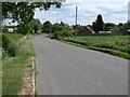
4
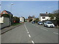
Ashby Road, Gilmorton
Heading north on National Cycle Route 50.
Image: © JThomas
Taken: 29 Mar 2014
0.10 miles
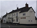
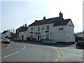
6
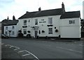
Gilmorton-The Red Lion
Public House on the corner of Main Street and Church Lane.
Image: © Ian Rob
Taken: 28 May 2011
0.13 miles
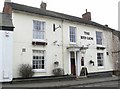
7
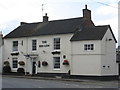
Gilmorton Red Lion
Main Street. Modernised village pub.
Image: © the bitterman
Taken: 9 Jul 2011
0.13 miles
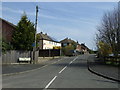
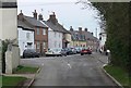
9
The Red Lion Pub in Gilmorton
On Main Street in Gilmorton, Leicestershire.
Image: © Mat Fascione
Taken: 24 Feb 2008
0.14 miles