IMAGES TAKEN NEAR TO
Dunton Road, LUTTERWORTH, LE17 5HQ
Introduction
This page details the photographs taken nearby to Dunton Road, LE17 5HQ by members of the Geograph project.
The Geograph project started in 2005 with the aim of publishing, organising and preserving representative images for every square kilometre of Great Britain, Ireland and the Isle of Man.

There are currently over 7.5m images from over14,400 individuals and you can help contribute to the project by visiting https://www.geograph.org.uk
Image Map
Images are licensed for reuse under creativecommons.org/licenses/by-sa/2.0
Notes
- Clicking on the map will re-center to the selected point.
- The higher the marker number, the further away the image location is from the centre of the postcode.
Image Listing (7 Images Found)
Images are licensed for reuse under creativecommons.org/licenses/by-sa/2.0
Image
Details
Distance
1
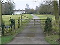
Leire Mill
Along Dunton Lane, close to the Leicestershire village of Leire. Leire Mill is a former Mill House dating from 1773, now a private residence.
Image: © Mat Fascione
Taken: 24 Feb 2008
0.05 miles
2
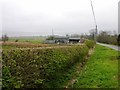
Leire
Rundown farm buildings at Far Hill Farm on Dunton Lane
Image: © Ian Rob
Taken: 21 Apr 2006
0.11 miles
3
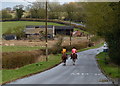
Horse riders on Dunton Road
The derelict buildings are at Far Hill Farm.
Image: © Mat Fascione
Taken: 18 Apr 2013
0.18 miles
4
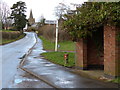
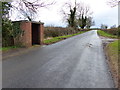
Bus shelter on Dunton Road
Looking towards St Peter's Church in the village of Leire.
Image: © Mat Fascione
Taken: 18 Apr 2013
0.18 miles
6
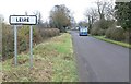
Welcome to Leire
North along Leire Lane.
Image: © Mat Fascione
Taken: 17 Nov 2007
0.19 miles
7
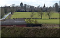
Farm buildings along Leire Lane
Looking towards St Peter's Church in the village of Leire.
Image: © Mat Fascione
Taken: 18 Apr 2013
0.20 miles