IMAGES TAKEN NEAR TO
Wales Orchard, LUTTERWORTH, LE17 5ES
Introduction
This page details the photographs taken nearby to Wales Orchard, LE17 5ES by members of the Geograph project.
The Geograph project started in 2005 with the aim of publishing, organising and preserving representative images for every square kilometre of Great Britain, Ireland and the Isle of Man.

There are currently over 7.5m images from over14,400 individuals and you can help contribute to the project by visiting https://www.geograph.org.uk
Image Map
Images are licensed for reuse under creativecommons.org/licenses/by-sa/2.0
Notes
- Clicking on the map will re-center to the selected point.
- The higher the marker number, the further away the image location is from the centre of the postcode.
Image Listing (29 Images Found)
Images are licensed for reuse under creativecommons.org/licenses/by-sa/2.0
Image
Details
Distance
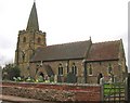
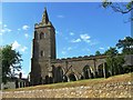
2
Leire
Queens Arms Public House looking from St Peter's Churchyard.
Image: © Ian Rob
Taken: 21 Apr 2006
0.06 miles
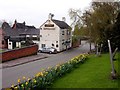
4
Leire Village Hall
On the corner of Main Street and Back Lane.
Image: © Ian Rob
Taken: 17 Feb 2015
0.06 miles
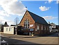
5

Leire-The White Horse Inn
One of two Public Houses in the village.
Image: © Ian Rob
Taken: 17 Feb 2015
0.07 miles
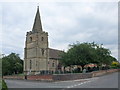
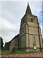
6
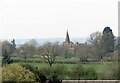
St Peter Leire seen from Dunton Lane
See Image for the wider view.
Image: © Andrew Tatlow
Taken: 31 Mar 2021
0.07 miles