IMAGES TAKEN NEAR TO
Andrews Close, LUTTERWORTH, LE17 5ER
Introduction
This page details the photographs taken nearby to Andrews Close, LE17 5ER by members of the Geograph project.
The Geograph project started in 2005 with the aim of publishing, organising and preserving representative images for every square kilometre of Great Britain, Ireland and the Isle of Man.

There are currently over 7.5m images from over14,400 individuals and you can help contribute to the project by visiting https://www.geograph.org.uk
Image Map
Images are licensed for reuse under creativecommons.org/licenses/by-sa/2.0
Notes
- Clicking on the map will re-center to the selected point.
- The higher the marker number, the further away the image location is from the centre of the postcode.
Image Listing (6 Images Found)
Images are licensed for reuse under creativecommons.org/licenses/by-sa/2.0
Image
Details
Distance
1
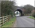
Broughton Lane towards Leire
The bridge carries the disused Rugby-Leicester railway line.
Image: © Mat Fascione
Taken: 24 Feb 2008
0.04 miles
2
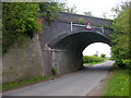
Leire-Boughton Lane Bridge
Looking north out of the village under the bridge which carried the Rugby-Leicester Line
Image: © Ian Rob
Taken: 28 Apr 2009
0.05 miles
3
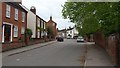
Leire
A view of the village centre.
Image: © Peter Mackenzie
Taken: 29 Apr 2017
0.15 miles
4
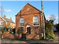
Leire-Former Wesleyan Chapel
Dating from 1863.
Image: © Ian Rob
Taken: 17 Feb 2015
0.17 miles
5
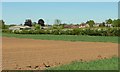
The village of Leire in Leicestershire
Image: © Mat Fascione
Taken: 22 May 2010
0.20 miles
6
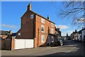
Leire-Glebe Farm House
Looking south down Main Street
Image: © Ian Rob
Taken: 17 Feb 2015
0.21 miles