IMAGES TAKEN NEAR TO
South View, Main Street, LUTTERWORTH, LE17 5EF
Introduction
This page details the photographs taken nearby to South View, Main Street, LE17 5EF by members of the Geograph project.
The Geograph project started in 2005 with the aim of publishing, organising and preserving representative images for every square kilometre of Great Britain, Ireland and the Isle of Man.

There are currently over 7.5m images from over14,400 individuals and you can help contribute to the project by visiting https://www.geograph.org.uk
Image Map
Images are licensed for reuse under creativecommons.org/licenses/by-sa/2.0
Notes
- Clicking on the map will re-center to the selected point.
- The higher the marker number, the further away the image location is from the centre of the postcode.
Image Listing (17 Images Found)
Images are licensed for reuse under creativecommons.org/licenses/by-sa/2.0
Image
Details
Distance
1
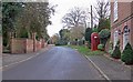
The Main Street in Frolesworth, Leicestershire
Image: © Mat Fascione
Taken: 17 Nov 2007
0.01 miles
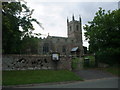
2
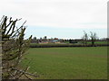
Frolesworth view
A view of Frolesworth from the Sharnford road.
The photograph was taken from just inside the top left hand corner of this square.
The hedge at the left hand side of the image is the boundary of the field and the road.
Image: © Roy William Shakespeare
Taken: 11 Mar 2007
0.02 miles
3
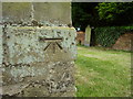
Nineteenth-century benchmark on Frolesworth church
This bench mark was established in 1856 during the First primary levelling of England & Wales, and was levelled with a height of 372.6280 feet [113.5770 metres] above mean sea level (Liverpool datum). It was included as a side level on the Coventry to Lincoln levelling line. The surveyor's description was "No. 32(a). Frowlesworth Church. Bolt in North-west angle of tower ; 1.99 ft. above surface" (Public Abstract p.326).
Image: © Shantavira
Taken: 10 Jun 2015
0.03 miles

5
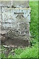
Bench mark, St Nicholas's Church, Frolesworth
See http://www.geograph.org.uk/photo/4956462 for location and http://www.geograph.org.uk/photo/4519378 for a full description.
Image: © Alan Murray-Rust
Taken: 15 May 2016
0.03 miles
6
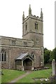
Church of St Nicholas, Frolesworth
The tower, from the north east. There is a bench mark http://www.geograph.org.uk/photo/4956452 on the visible corner of the tower.
Image: © Alan Murray-Rust
Taken: 15 May 2016
0.03 miles

9
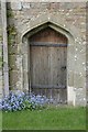
Church of St Nicholas, Frolesworth
The south doorway, 15th century. The strapwork is crudely decorated and may be old.
Image: © Alan Murray-Rust
Taken: 15 May 2016
0.04 miles
10
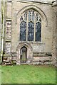
Church of St Nicholas, Frolesworth
Priest's door and window in the north side of the chancel, 15th century Perpendicular.
Image: © Alan Murray-Rust
Taken: 15 May 2016
0.04 miles