IMAGES TAKEN NEAR TO
South Avenue, LUTTERWORTH, LE17 5DG
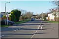
Introduction
This page details the photographs taken nearby to South Avenue, LE17 5DG by members of the Geograph project.
The Geograph project started in 2005 with the aim of publishing, organising and preserving representative images for every square kilometre of Great Britain, Ireland and the Isle of Man.

There are currently over 7.5m images from over14,400 individuals and you can help contribute to the project by visiting https://www.geograph.org.uk
Image Map
Images are licensed for reuse under creativecommons.org/licenses/by-sa/2.0
Notes
- Clicking on the map will re-center to the selected point.
- The higher the marker number, the further away the image location is from the centre of the postcode.
Image Listing (68 Images Found)
Images are licensed for reuse under creativecommons.org/licenses/by-sa/2.0
Image
Details
Distance
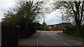
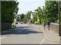
1
View along Main Street, Ullesthorpe
At its junction with Ashby Road.
Image: © Mat Fascione
Taken: 23 Nov 2007
0.06 miles
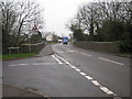
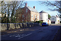
2
Ullesthorpe
The approach to Ullesthorpe from Ashby Parva.
Image: © Peter Mackenzie
Taken: 29 Apr 2017
0.06 miles
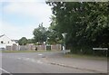
3
Ullesthorpe Station
View from road bridge (Main Street) at Ullesthorpe, looking south at trackbed and through foliage, the remains of Ullesthorpe Station.
Image: © Michael Westley
Taken: 15 Dec 2009
0.07 miles
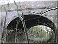
5
Road bridge, Main Street, Ullesthorpe
Bridge under which Rugby - Leicester railway line once was, just north of site of Ullesthorpe Station
Image: © Michael Westley
Taken: 15 Dec 2009
0.07 miles
6
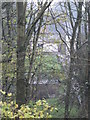
Ullesthorpe Station
Closeup of station remains, one platform can clearly be seen through trees on right. Photo taken from road bridge (Main Street)
Image: © Michael Westley
Taken: 15 Dec 2009
0.08 miles
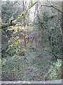
7
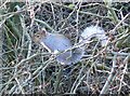
An Ullesthorpe resident
In the trees along the former route of the Rugby railway line, close to the Main Street bridge.
Image: © Mat Fascione
Taken: 23 Nov 2007
0.08 miles
8
Main Street, Ullesthorpe
At this point Main Street crosses the route of the Leicester - Rugby railway line (opened 1840, closed 1961). For the first 59 years of its existence the station at Ullesthorpe was the nearest access to the railway for the town of Lutterworth, 5.5 km away.
Image: © Kevin Flynn
Taken: 10 Jun 2006
0.08 miles
9
Ullesthorpe-Dismantled Railway
The Lutterworth Road bridge.The site of the Station is 100 metres south of the bridge.The platform remains and the Station house is now privately owned.
Image: © Ian Rob
Taken: 26 Feb 2010
0.08 miles
10
Main Street, Ullesthorpe
In the foreground is the bridge over the disused Rugby - Leicester railway and the site of Ullesthorpe station was on the right. Despite appearances, the houses in this view are new builds including the unusual 'Round House' which was designed to 'reflect the iconic mill' and 'offer a unique lifestyle home'.
Image: © Stephen McKay
Taken: 1 Dec 2020
0.08 miles