IMAGES TAKEN NEAR TO
Valley Lane, LUTTERWORTH, LE17 4SA
Introduction
This page details the photographs taken nearby to Valley Lane, LE17 4SA by members of the Geograph project.
The Geograph project started in 2005 with the aim of publishing, organising and preserving representative images for every square kilometre of Great Britain, Ireland and the Isle of Man.

There are currently over 7.5m images from over14,400 individuals and you can help contribute to the project by visiting https://www.geograph.org.uk
Image Map
Images are licensed for reuse under creativecommons.org/licenses/by-sa/2.0
Notes
- Clicking on the map will re-center to the selected point.
- The higher the marker number, the further away the image location is from the centre of the postcode.
Image Listing (43 Images Found)
Images are licensed for reuse under creativecommons.org/licenses/by-sa/2.0
Image
Details
Distance
1
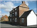
Bitteswell-The Olde Royal Oak
Public house near the School in Valley Road.
Image: © Ian Rob
Taken: 4 Mar 2008
0.04 miles
3
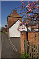
The Olde Royal Oak, Bitteswell
The Olde Royal Oak on Valley Lane in the heart of Bitteswell dates from the 17th century. The entrance to the car park is in the foreground.
Image: © Stephen McKay
Taken: 15 Apr 2012
0.05 miles
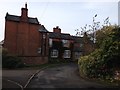
5
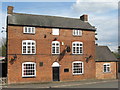
Bitteswell Olde Royal Oak
Valley Lane. Grade II listed pub.
Image: © the bitterman
Taken: 6 May 2012
0.06 miles
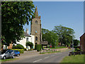
7
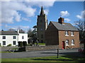
Bitteswell Village
Looking from The Green past the cottage on Manor Road to Saint Marys Church.
Image: © Ian Rob
Taken: 4 Mar 2008
0.09 miles
8
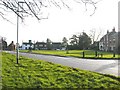
Bitteswell
Village Green looking south east.
Image: © Ian Rob
Taken: 31 Dec 2005
0.09 miles
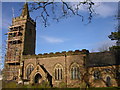
10
Bitteswell
St Mary's church and Lutterworth Road
Image: © Kevin Flynn
Taken: 10 Jun 2006
0.09 miles