IMAGES TAKEN NEAR TO
Coventry Road, LUTTERWORTH, LE17 4RB
Introduction
This page details the photographs taken nearby to Coventry Road, LE17 4RB by members of the Geograph project.
The Geograph project started in 2005 with the aim of publishing, organising and preserving representative images for every square kilometre of Great Britain, Ireland and the Isle of Man.

There are currently over 7.5m images from over14,400 individuals and you can help contribute to the project by visiting https://www.geograph.org.uk
Image Map
Images are licensed for reuse under creativecommons.org/licenses/by-sa/2.0
Notes
- Clicking on the map will re-center to the selected point.
- The higher the marker number, the further away the image location is from the centre of the postcode.
Image Listing (92 Images Found)
Images are licensed for reuse under creativecommons.org/licenses/by-sa/2.0
Image
Details
Distance
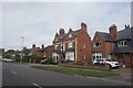
2
Wycliffe memorial and Methodist Church
At the junction of Coventry Road and Bitteswell Road in Lutterworth, Leicestershire.
Image: © Mat Fascione
Taken: 23 Nov 2007
0.07 miles
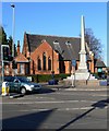
3
Wycliffe Memorial Methodist Church, Lutterworth
The obelisk to the left of the church, on the corner of Coventry Road and Bitteswell Road, commemorates John Wycliffe, a 14th century clergyman, who is credited with translating the bible into English for the first time. He is thought to have been born in Yorkshire but became rector of Lutterworth. He believed that the bible should be accessible to all, and not just the preserve of the clergy. Although he died peacefully in Lutterworth, his views were later declared heretical.
Image: © Stephen McKay
Taken: 15 Apr 2007
0.07 miles
4
Lutterworth Cricket Ground
Lutterworth Cricket Club have been established at this attractive Coventry Road ground for over 100 years. A new pavilion was built in 1995 after the previous one burnt down.
Image: © Stephen McKay
Taken: 15 Apr 2007
0.08 miles
5
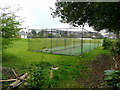
Practice nets
In the corner of Lutterworth cricket ground.
Image: © Jonathan Billinger
Taken: 18 Apr 2008
0.09 miles
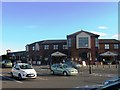
6
Bitteswell Road, Lutterworth
Showing Bitteswell Road from its junction with Coventry Road. Morrisons is the largest supermarket in the town, although it is a relatively small branch of the chain.
Image: © Stephen McKay
Taken: 15 Apr 2007
0.10 miles
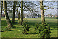
9
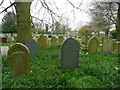
St. Mary's churchyard
A large, well-kept space as befits a prosperous market town.
Image: © Jonathan Billinger
Taken: 18 Apr 2008
0.13 miles
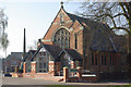
10

Lutterworth Church
Blossom and the tower of St Mary's church on a gloriously sunny Sunday morning.
Image: © Stephen McKay
Taken: 15 Apr 2007
0.13 miles