IMAGES TAKEN NEAR TO
Leicester Road, LUTTERWORTH, LE17 4PW
Introduction
This page details the photographs taken nearby to Leicester Road, LE17 4PW by members of the Geograph project.
The Geograph project started in 2005 with the aim of publishing, organising and preserving representative images for every square kilometre of Great Britain, Ireland and the Isle of Man.

There are currently over 7.5m images from over14,400 individuals and you can help contribute to the project by visiting https://www.geograph.org.uk
Image Map
Images are licensed for reuse under creativecommons.org/licenses/by-sa/2.0
Notes
- Clicking on the map will re-center to the selected point.
- The higher the marker number, the further away the image location is from the centre of the postcode.
Image Listing (28 Images Found)
Images are licensed for reuse under creativecommons.org/licenses/by-sa/2.0
Image
Details
Distance
1
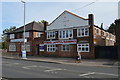
Carpet Warehouse - Lower Leicester Road
Former drill hall used as base by D Squadron, Leicestershire Yeomanry, prior to the Great War.
Image: © John M
Taken: 12 Oct 2014
0.10 miles

3
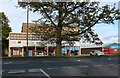
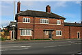
Elizabethan House on Leicester Road, Lutterworth
Image: © David Howard
Taken: 16 May 2021
0.17 miles
5
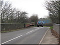
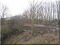
Gilmorton Road Bridge, Great Central Railway
Taken from north side of road, opposite start of ROW south alongside the trackbed, the remains of metal structure of the railway bridge, above filled in archway can be seen. Viewed looking towards Lutterworth. Not far from Museum (just along road on right).
Image: © Michael Westley
Taken: 4 Dec 2009
0.18 miles
7
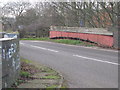
Gilmorton Road Bridge, Great Central Railway
Viewed from part way down ROW footpath (at gate), view of bridge walls and bridge structure remains, showing slope that goes down to trackbed.
Image: © Michael Westley
Taken: 4 Dec 2009
0.18 miles
8
Gilmorton Road Bridge, Great Central Railway
Standing at driveway/footpath that heads south, view of remains of bridge that once crossed the railway line north of Lutterworth Station. The line beneath the bridge has been filled in.
Image: © Michael Westley
Taken: 4 Dec 2009
0.20 miles

10
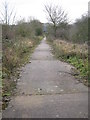
Footpath near Gilmorton Road Bridge, Lutterworth
Concrete track, just beyond gate near Gilmorton Road, showing footpath / ROW down to old trackbed, looking in direction of Lutterworth Station. The trackbed beyond this photo are variously now covered by housing and factory units.
Image: © Michael Westley
Taken: 4 Dec 2009
0.21 miles