IMAGES TAKEN NEAR TO
Lower Leicester Road, LUTTERWORTH, LE17 4NF
Introduction
This page details the photographs taken nearby to Lower Leicester Road, LE17 4NF by members of the Geograph project.
The Geograph project started in 2005 with the aim of publishing, organising and preserving representative images for every square kilometre of Great Britain, Ireland and the Isle of Man.

There are currently over 7.5m images from over14,400 individuals and you can help contribute to the project by visiting https://www.geograph.org.uk
Image Map
Images are licensed for reuse under creativecommons.org/licenses/by-sa/2.0
Notes
- Clicking on the map will re-center to the selected point.
- The higher the marker number, the further away the image location is from the centre of the postcode.
Image Listing (52 Images Found)
Images are licensed for reuse under creativecommons.org/licenses/by-sa/2.0
Image
Details
Distance
3
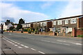
Carpet Warehouse - Lower Leicester Road
Former drill hall used as base by D Squadron, Leicestershire Yeomanry, prior to the Great War.
Image: © John M
Taken: 12 Oct 2014
0.05 miles
4

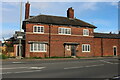
Lutterworth Police Station
Closed and For Sale.
Image: © Ian Rob
Taken: 1 Apr 2014
0.07 miles

9
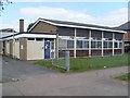
Lutterworth Telephone Exchange
Situated on the A426 Lower Leicester Road, this TE, of a standard design common throughout the United Kingdom, replaced the former Manual TE sometime during the 1960s. Besides Lutterworth, this TE also serves Bitteswell, Cotesbach, Gilmorton, Kimcote, Misterton, Walcote and Walton nearby. The numbering range of this TE is (01455) 55xxxx, the (01455) referring to the Hinckley group of TEs, and its postcode is LE17 4NF.
Image: © David Hillas
Taken: 31 Aug 2013
0.08 miles
10
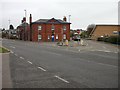
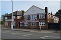
Lutterworth-Police Station
At the junction of High Street and Gilmorton Road.
Image: © Ian Rob
Taken: 27 Oct 2007
0.08 miles