IMAGES TAKEN NEAR TO
Swinford Road, LUTTERWORTH, LE17 4JZ
Introduction
This page details the photographs taken nearby to Swinford Road, LE17 4JZ by members of the Geograph project.
The Geograph project started in 2005 with the aim of publishing, organising and preserving representative images for every square kilometre of Great Britain, Ireland and the Isle of Man.

There are currently over 7.5m images from over14,400 individuals and you can help contribute to the project by visiting https://www.geograph.org.uk
Image Map
Images are licensed for reuse under creativecommons.org/licenses/by-sa/2.0
Notes
- Clicking on the map will re-center to the selected point.
- The higher the marker number, the further away the image location is from the centre of the postcode.
Image Listing (8 Images Found)
Images are licensed for reuse under creativecommons.org/licenses/by-sa/2.0
Image
Details
Distance
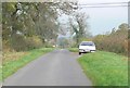
1
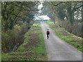
Cycling along Swinford Road
National Cycle Route 70 follows this road.
Image: © Mat Fascione
Taken: 3 Nov 2007
0.03 miles
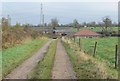
2

Walcote
Sheds on Swinford road near Orchard Farm
Image: © Ian Rob
Taken: 4 Apr 2006
0.12 miles
3
London Lodge
South of the village of Walcote in Leicestershire.
Image: © Mat Fascione
Taken: 3 Nov 2007
0.13 miles
4
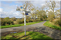
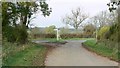
Swinford Road, Walcote
Although this appears to be a road junction the route to the rear of the photographer is really only a track signed 'unsuitable for motor vehicles'. Nevertheless, this fingerpost points the way to Walcote and Swinford.
Image: © Stephen McKay
Taken: 28 Oct 2018
0.14 miles
5

Signpost on Swinford Road
A close-up view of the signpost seen here: Image
Image: © Stephen McKay
Taken: 28 Oct 2018
0.15 miles
6
Swinford Road junction
South of the village of Walcote in Leicestershire.
Image: © Mat Fascione
Taken: 3 Nov 2007
0.16 miles
7
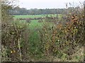
Farmland off Swinford Road
South of the village of Walcote in Leicestershire.
Image: © Mat Fascione
Taken: 3 Nov 2007
0.23 miles