IMAGES TAKEN NEAR TO
Cromwell Close, LUTTERWORTH, LE17 4JJ
Introduction
This page details the photographs taken nearby to Cromwell Close, LE17 4JJ by members of the Geograph project.
The Geograph project started in 2005 with the aim of publishing, organising and preserving representative images for every square kilometre of Great Britain, Ireland and the Isle of Man.

There are currently over 7.5m images from over14,400 individuals and you can help contribute to the project by visiting https://www.geograph.org.uk
Image Map
Images are licensed for reuse under creativecommons.org/licenses/by-sa/2.0
Notes
- Clicking on the map will re-center to the selected point.
- The higher the marker number, the further away the image location is from the centre of the postcode.
Image Listing (33 Images Found)
Images are licensed for reuse under creativecommons.org/licenses/by-sa/2.0
Image
Details
Distance
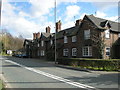
1
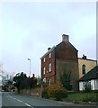
Houses at Walcote
The houses in the middle distance are on Cromwell Close and date from the late 1960s/early 1970s period. The Cromwell name commemorates a past owner of nearby Misterton Hall.
Image: © Stephen McKay
Taken: 18 Aug 2022
0.03 miles
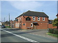
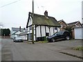
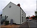
2
The Black Horse, Walcote
Despite appearances, which might suggest a local health centre or the offices of a light engineering company, this is very much a thriving village pub. In fact it was rescued in 2016, having been closed since 2012, by the village’s Community Benefit Society who bought and refurbished the building.
Image: © Stephen McKay
Taken: 28 Oct 2018
0.04 miles
4
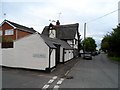
Thatched building, Walcote
The thatched building is late C17/early C18. See http://www.britishlistedbuildings.co.uk/en-191434-no-1-and-attached-outbuilding-range-mist
Image: © Bikeboy
Taken: 21 Aug 2014
0.06 miles
5
Walcote-The Old Post Office
On Brook Street, now converted.
Image: © Ian Rob
Taken: 12 Feb 2015
0.06 miles
7
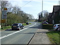
A bend in Lutterworth Road (A4304)
Heading east towards Market Harborough.
Image: © JThomas
Taken: 29 Mar 2014
0.08 miles
8
Walcote-Lutterworth Road
Houses dating from 1855, close to the road to South Kilworth.
Image: © Ian Rob
Taken: 4 Mar 2008
0.09 miles
9
The former Tavern Inn, Walcote
It seems to be in the process of being converted to residential use.
Image: © Bikeboy
Taken: 21 Aug 2014
0.10 miles