IMAGES TAKEN NEAR TO
Rugby Road, LUTTERWORTH, LE17 4HN
Introduction
This page details the photographs taken nearby to Rugby Road, LE17 4HN by members of the Geograph project.
The Geograph project started in 2005 with the aim of publishing, organising and preserving representative images for every square kilometre of Great Britain, Ireland and the Isle of Man.

There are currently over 7.5m images from over14,400 individuals and you can help contribute to the project by visiting https://www.geograph.org.uk
Image Map
Images are licensed for reuse under creativecommons.org/licenses/by-sa/2.0
Notes
- Clicking on the map will re-center to the selected point.
- The higher the marker number, the further away the image location is from the centre of the postcode.
Image Listing (56 Images Found)
Images are licensed for reuse under creativecommons.org/licenses/by-sa/2.0
Image
Details
Distance
1
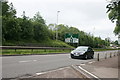
Lutterworth A4303 (Site of Great Central Railway bridge)
South of Lutterworth, between M1 junction and "Whittle" island, Great Central Railway used to cross what is now A4303. The brickwork supporting the remaining embankment can be seen to left of large roadsign, behind barrier (opposite side of road).
Image: © Michael Westley
Taken: 27 May 2009
0.03 miles
2
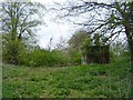
Lutterworth-Great Central Railway
The site of the dismantled bridge across the A4303. A brick built line side building remains.
Image: © Ian Rob
Taken: 14 Apr 2011
0.03 miles
3
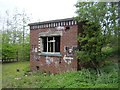
Lutterworth-Great Central Railway
A brick built line side building remains near the site of the dismantled bridge across the A4303.
Image: © Ian Rob
Taken: 14 Apr 2011
0.03 miles
4
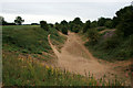
Line of railway
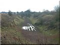
To the south of Lutterworth on the historical map this is marked as the line of the London and North Eastern Railway. It was built as the Great Central Railway.
The picture was taken during a period of drought with very little rainfall over the last couple of months, obviously this was not true of Image
Image: © David Lally
Taken: 8 Jul 2010
0.06 miles
5
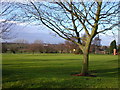
Lutterworth
Lutterworth Golf Course, close to the clubhouse.
Image: © Ian Rob
Taken: 31 Dec 2005
0.07 miles
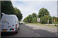
6

View towards St Mary Church, Lutterworth
The memorial to Frank Whittle is on a roundabout just off the left of the picture.
The Travelodge and The Elms public house are visible to the right of the picture.
Image: © Mat Fascione
Taken: 3 Nov 2007
0.08 miles
7
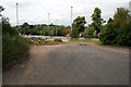
Dead end on Rugby Road
The old course of the road is now cut-off at the Whittle Roundabout.
Image: © David Lally
Taken: 7 Jul 2010
0.09 miles
8
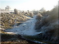
Disused railway neat Lutterworth
On a frosty December afternoon.
Image: © Graham Hogg
Taken: 7 Dec 2010
0.09 miles
10
Lutterworth
Facing south down Great Central railway cutting from Swinford Rd.
Image: © Ian Rob
Taken: 21 Dec 2005
0.10 miles