IMAGES TAKEN NEAR TO
Beamont Close, LUTTERWORTH, LE17 4GE
Introduction
This page details the photographs taken nearby to Beamont Close, LE17 4GE by members of the Geograph project.
The Geograph project started in 2005 with the aim of publishing, organising and preserving representative images for every square kilometre of Great Britain, Ireland and the Isle of Man.

There are currently over 7.5m images from over14,400 individuals and you can help contribute to the project by visiting https://www.geograph.org.uk
Image Map
Images are licensed for reuse under creativecommons.org/licenses/by-sa/2.0
Notes
- Clicking on the map will re-center to the selected point.
- The higher the marker number, the further away the image location is from the centre of the postcode.
Image Listing (15 Images Found)
Images are licensed for reuse under creativecommons.org/licenses/by-sa/2.0
Image
Details
Distance
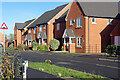
1
Poppy Road, Lutterworth
Poppy Road runs in a crescent off Bill Crane Way on the northern edge of Lutterworth. It is a recent development, called 'Saxon Meadow' by the builder, William Davis Homes.
Image: © Stephen McKay
Taken: 1 Dec 2020
0.08 miles
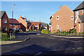
2
Burrough Way, Lutterworth
Lutterworth has expanded considerably in recent years and these houses are part of an extensive development to the north of the town centre.
Image: © Stephen McKay
Taken: 1 Dec 2020
0.11 miles
3
Primrose Close, Lutterworth
Part of the Saxon Meadow development on the northern edge of Lutterworth with a drainage stream in the foreground.
Image: © Stephen McKay
Taken: 1 Dec 2020
0.14 miles
4
Poppy Road, Lutterworth
This is the eastern end of Poppy Road, seen from its junction with Bill Crane Way, part of the Saxon Meadow development.
Image: © Stephen McKay
Taken: 1 Dec 2020
0.14 miles
5
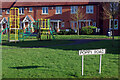
Poppy Road, Lutterworth
A small green area is provided in the heart of the Saxon Meadow development where some children's play equipment has been provided.
Image: © Stephen McKay
Taken: 1 Dec 2020
0.14 miles
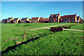
6
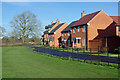
Primrose Close, Lutterworth
These new houses look out over a playing field area and, beyond that, open countryside. They are part of the Saxon Meadow development built by William Davis Homes.
Image: © Stephen McKay
Taken: 1 Dec 2020
0.15 miles
7
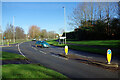
Bill Crane Way, Lutterworth
Bill Crane Way is a modern road that sweeps round the north western edge of Lutterworth; it is named after a former Chairman of Harborough District Council. The road to Bitteswell and Ullesthorpe leads off to the left.
Image: © Stephen McKay
Taken: 1 Dec 2020
0.19 miles
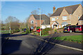
8
South along the A426 Leicester Road
On the northern edge of the Leicestershire town of Lutterworth.
Image: © Mat Fascione
Taken: 22 Jun 2008
0.19 miles
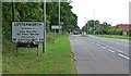
9
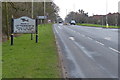
Welcome to Lutterworth
Looking south along the A426 Leicester Road, on the right is the junction for Bill Crane Way. The sign has changed since Image
Image: © Mat Fascione
Taken: 6 Jan 2013
0.19 miles
10
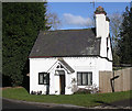
Old Toll House by Lutterworth Road, Bitteswell
Toll House in the parish of Bitteswell (Harborough District), Toll Gate House, Lutterworth Road, at its junction with Bill Crane Way, LE17 4RX.
Leicestershire and Rutland HER.
HER Ref: MLE18542 https://www.heritagegateway.org.uk/Gateway/Results_Single.aspx?uid=MLE18542&resourceID=1021
Surveyed
Milestone Society National ID: LE.BIT
Image: © Alan Rosevear
Taken: Unknown
0.19 miles