IMAGES TAKEN NEAR TO
Mulberry Close, LUTTERWORTH, LE17 4DF
Introduction
This page details the photographs taken nearby to Mulberry Close, LE17 4DF by members of the Geograph project.
The Geograph project started in 2005 with the aim of publishing, organising and preserving representative images for every square kilometre of Great Britain, Ireland and the Isle of Man.

There are currently over 7.5m images from over14,400 individuals and you can help contribute to the project by visiting https://www.geograph.org.uk
Image Map
Images are licensed for reuse under creativecommons.org/licenses/by-sa/2.0
Notes
- Clicking on the map will re-center to the selected point.
- The higher the marker number, the further away the image location is from the centre of the postcode.
Image Listing (3 Images Found)
Images are licensed for reuse under creativecommons.org/licenses/by-sa/2.0
Image
Details
Distance
1
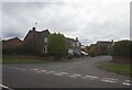
Mulberry Close off Brookfield Way, Lutterworth
Image: © Ian S
Taken: 19 Aug 2021
0.04 miles
2
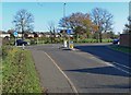
Brookfield Way, Lutterworth
At its junction with Bitteswell Road, turn right for Lutterworth town centre, left leads to Bitteswell.
Image: © Mat Fascione
Taken: 23 Nov 2007
0.15 miles
3
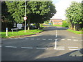
Southern entrance to Macaulay Drive in Lutterworth
Image: © Peter Robinson
Taken: 18 Jul 2012
0.21 miles