IMAGES TAKEN NEAR TO
Rugby Road, LUTTERWORTH, LE17 4BW
Introduction
This page details the photographs taken nearby to Rugby Road, LE17 4BW by members of the Geograph project.
The Geograph project started in 2005 with the aim of publishing, organising and preserving representative images for every square kilometre of Great Britain, Ireland and the Isle of Man.

There are currently over 7.5m images from over14,400 individuals and you can help contribute to the project by visiting https://www.geograph.org.uk
Image Map
Images are licensed for reuse under creativecommons.org/licenses/by-sa/2.0
Notes
- Clicking on the map will re-center to the selected point.
- The higher the marker number, the further away the image location is from the centre of the postcode.
Image Listing (117 Images Found)
Images are licensed for reuse under creativecommons.org/licenses/by-sa/2.0
Image
Details
Distance
1
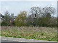
Housing in Lutterworth.
Viewed from the office park (Image) with the tower of St. Mary's sitting squarely.
The River Swift flows past the trees in the foreground.
Image: © Jonathan Billinger
Taken: 18 Apr 2008
0.00 miles
2
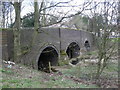
Lutterworth-River Swift
The bridge carrying the A426 Rugby Road over the river.
Image: © Ian Rob
Taken: 4 Mar 2008
0.05 miles
3
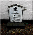
Milestone / Milepost, A426 Lutterworth
Against the house, "the Springs", 1 Rugby Rd. (to Market Harborough)
To / Harboro / 13 Miles / Rugby / 8 Miles / Daventry / 15 Miles
Milestone Society National ID: LE_LURY08
Image: © Sharon Penhallurick
Taken: Unknown
0.05 miles
4
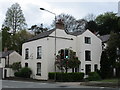
The Springs, Lutterworth
Sixteenth century house with later extensions http://www.britishlistedbuildings.co.uk/101211221-the-springs-lutterworth#.WQpJCsa1usw
Image: © Jonathan Thacker
Taken: 28 Apr 2017
0.05 miles
5
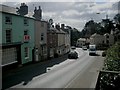
Lutterworth-High Street
Heading away from the Town Centre.
Image: © Ian Rob
Taken: 4 Mar 2008
0.06 miles
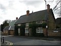
7
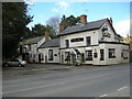
Lutterworth-The Fox Inn
At the southern end of town, on Rugby Road.
Image: © Ian Rob
Taken: 4 Mar 2008
0.08 miles
9
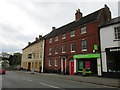
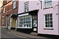
22 High Street and the Denbigh Arms Hotel
22 High Street dates from the early nineteenth century http://www.britishlistedbuildings.co.uk/101209171-22-high-street-lutterworth#.WQpKg8a1usw and the Denbigh Arms Hotel is of similar age. These and other buildings suggest that Lutterworth was relatively prosperous at this time.
Image: © Jonathan Thacker
Taken: 28 Apr 2017
0.10 miles
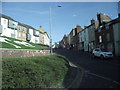
10
Lutterworth-Woodmarket
The sign on the house says Regent Street but the sign on the wall says Woodmarket.
Image: © Ian Rob
Taken: 4 Mar 2008
0.10 miles