IMAGES TAKEN NEAR TO
Torch Way, MARKET HARBOROUGH, LE16 9HL
Introduction
This page details the photographs taken nearby to Torch Way, LE16 9HL by members of the Geograph project.
The Geograph project started in 2005 with the aim of publishing, organising and preserving representative images for every square kilometre of Great Britain, Ireland and the Isle of Man.

There are currently over 7.5m images from over14,400 individuals and you can help contribute to the project by visiting https://www.geograph.org.uk
Image Map
Images are licensed for reuse under creativecommons.org/licenses/by-sa/2.0
Notes
- Clicking on the map will re-center to the selected point.
- The higher the marker number, the further away the image location is from the centre of the postcode.
Image Listing (24 Images Found)
Images are licensed for reuse under creativecommons.org/licenses/by-sa/2.0
Image
Details
Distance
1
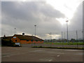
Market Harborough Rugby Union F C ground
http://www.marketharboroughrufc.co.uk/
Image: © Steve Fareham
Taken: 21 Nov 2007
0.06 miles
2
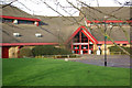
Harborough Leisure Centre
Modern leisure centre on the southern edge of Market Harborough.
Image: © Stephen McKay
Taken: 30 Dec 2006
0.07 miles
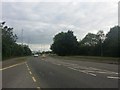
3
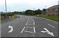
Northampton Road south of Market Harborough
Image: © Mat Fascione
Taken: 8 Oct 2007
0.08 miles
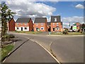
5
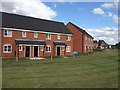
New housing on the south of Market Harborough
Image: © Dave Thompson
Taken: 17 Jul 2015
0.09 miles
6
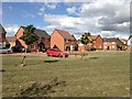
New housing on the south of Market Harborough
Image: © Dave Thompson
Taken: 17 Jul 2015
0.09 miles
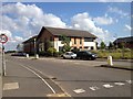
8
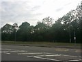
Bus stop on Northampton Road, Market Harborough
Image: © David Howard
Taken: 2 Jul 2019
0.11 miles
9
New housing on the south of Market Harborough
Image: © Dave Thompson
Taken: 17 Jul 2015
0.11 miles
10
New housing on the south of Market Harborough
Image: © Dave Thompson
Taken: 17 Jul 2015
0.13 miles