IMAGES TAKEN NEAR TO
The Pastures, MARKET HARBOROUGH, LE16 9EA
Introduction
This page details the photographs taken nearby to The Pastures, LE16 9EA by members of the Geograph project.
The Geograph project started in 2005 with the aim of publishing, organising and preserving representative images for every square kilometre of Great Britain, Ireland and the Isle of Man.

There are currently over 7.5m images from over14,400 individuals and you can help contribute to the project by visiting https://www.geograph.org.uk
Image Map
Images are licensed for reuse under creativecommons.org/licenses/by-sa/2.0
Notes
- Clicking on the map will re-center to the selected point.
- The higher the marker number, the further away the image location is from the centre of the postcode.
Image Listing (8 Images Found)
Images are licensed for reuse under creativecommons.org/licenses/by-sa/2.0
Image
Details
Distance
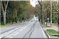
3
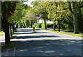
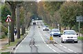
Lubenham Hill towards Market Harborough
Closer inspection of the sign reveals it may have been shot twice.
Image: © Mat Fascione
Taken: 8 Oct 2007
0.18 miles
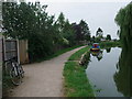
4
Canal towpath
On the Market Harborough arm of the Grand Union Canal.
Image: © Andrew Abbott
Taken: 26 Sep 2020
0.20 miles
5

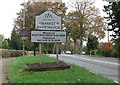
Footpath across the fields
This footpath leads from Harborough Road to Hill Gardens on the western edge of Market Harborough.
Image: © Mat Fascione
Taken: 25 May 2013
0.21 miles
6
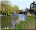
Market Harborough Branch of the Grand Union Canal
Image: © Mat Fascione
Taken: 26 Mar 2017
0.24 miles
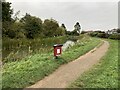
8
Grand Union Canal, Market Harborough Branch
Cycle Route 6 from Logan Street, Market Harborough, joins the canal towpath from the gap in the fence.
Image: © Tim Heaton
Taken: 3 Jul 2011
0.25 miles