IMAGES TAKEN NEAR TO
The Firs, MARKET HARBOROUGH, LE16 9BW
Introduction
This page details the photographs taken nearby to The Firs, LE16 9BW by members of the Geograph project.
The Geograph project started in 2005 with the aim of publishing, organising and preserving representative images for every square kilometre of Great Britain, Ireland and the Isle of Man.

There are currently over 7.5m images from over14,400 individuals and you can help contribute to the project by visiting https://www.geograph.org.uk
Image Map
Images are licensed for reuse under creativecommons.org/licenses/by-sa/2.0
Notes
- Clicking on the map will re-center to the selected point.
- The higher the marker number, the further away the image location is from the centre of the postcode.
Image Listing (19 Images Found)
Images are licensed for reuse under creativecommons.org/licenses/by-sa/2.0
Image
Details
Distance
3
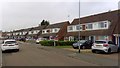
Willow Crescent
1960s semis in Market Harborough.
Image: © Burgess Von Thunen
Taken: 9 Nov 2018
0.16 miles
4
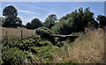
Highest bridging point
There may be higher bridging points across the Welland between here and the source, but if so they are on private land and inaccessible to a Geographists. This rustic composition of telegraph poles and railway sleepers appears solid, apart from the gap. A nearby homeowner told me the missing boarding had been removed by caravan dwelling itinerant scrap metal enthusiasts, probably (she said) to sell to landscape enthusiasts.
Image: © Bob Harvey
Taken: 7 Aug 2022
0.16 miles
5
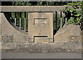
Datestone on the bridge
Built in 1931, this is the parapet seen in Image
Image: © Bob Harvey
Taken: 7 Aug 2022
0.17 miles
6
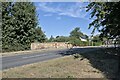
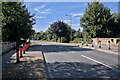
Bridge over the River Welland
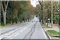
The Welland flows through Market Harborough, and there are several bridges provided to cross it. This one is in Welland Park Road, at one time the town's internal bypass although it reverted to a local road in the 1990s.
The cast concrete parapet bears the date 1931.
Image: © Bob Harvey
Taken: 7 Aug 2022
0.17 miles
7
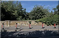
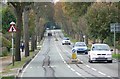
Bridge over the Welland
The northern parapet of Image, also including the curious traffic barriers that are fitted to the bridge.
Image: © Bob Harvey
Taken: 7 Aug 2022
0.17 miles
9
The Bridge over the Welland
The bridge over the Welland in Welland Park Road.
Image: © Bob Harvey
Taken: 7 Aug 2022
0.18 miles
10
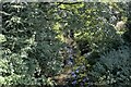
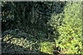
The River Welland
Looking upstream from the Image in Market Harborough.
Image: © Bob Harvey
Taken: 7 Aug 2022
0.18 miles