IMAGES TAKEN NEAR TO
East Carlton Park, MARKET HARBOROUGH, LE16 8YE
Introduction
This page details the photographs taken nearby to East Carlton Park, LE16 8YE by members of the Geograph project.
The Geograph project started in 2005 with the aim of publishing, organising and preserving representative images for every square kilometre of Great Britain, Ireland and the Isle of Man.

There are currently over 7.5m images from over14,400 individuals and you can help contribute to the project by visiting https://www.geograph.org.uk
Image Map
Images are licensed for reuse under creativecommons.org/licenses/by-sa/2.0
Notes
- Clicking on the map will re-center to the selected point.
- The higher the marker number, the further away the image location is from the centre of the postcode.
Image Listing (5 Images Found)
Images are licensed for reuse under creativecommons.org/licenses/by-sa/2.0
Image
Details
Distance
1
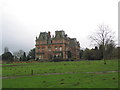
East Carlton Hall
In the grounds of the East Carlton Countryside Park. Built in 1863. Not open to the public
Image: © Tim Heaton
Taken: 29 Dec 2006
0.14 miles
2
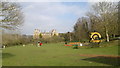
East Carlton Hall
More about East Carlton and its part in the development of nearby steel town, Corby, at; http://en.wikipedia.org/wiki/East_Carlton
The house is not open to the public and the grounds form part of East Carlton Country Park.
Image: © Chris Morgan
Taken: 5 Apr 2015
0.17 miles
3
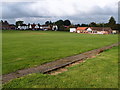
East Carlton cricket ground
Sloping outfield, level wicket and surrounded by houses. Built for the Corby Steelworks management, obviously west of the works. The cricket field and all manner of social amenities for the new steel works of Messrs Stewart's & Lloyd's Ltd, built from 1933.
Image: © Michael Trolove
Taken: 17 Sep 2017
0.19 miles
4
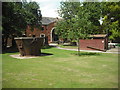
East Carlton Countryside Park
Coach house contains craft workshops and a Steel Heritage Centre relating to neighbouring Corby.
Image: © Jim Smillie
Taken: 17 Jul 2010
0.22 miles
5
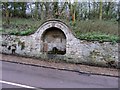
A trough on The Hill
The trough is fed by one of the springs that abound in the area
Image: © Andrew Tatlow
Taken: 13 Dec 2006
0.24 miles