IMAGES TAKEN NEAR TO
Uppingham Road, MARKET HARBOROUGH, LE16 8RY
Introduction
This page details the photographs taken nearby to Uppingham Road, LE16 8RY by members of the Geograph project.
The Geograph project started in 2005 with the aim of publishing, organising and preserving representative images for every square kilometre of Great Britain, Ireland and the Isle of Man.

There are currently over 7.5m images from over14,400 individuals and you can help contribute to the project by visiting https://www.geograph.org.uk
Image Map
Images are licensed for reuse under creativecommons.org/licenses/by-sa/2.0
Notes
- Clicking on the map will re-center to the selected point.
- The higher the marker number, the further away the image location is from the centre of the postcode.
Image Listing (4 Images Found)
Images are licensed for reuse under creativecommons.org/licenses/by-sa/2.0
Image
Details
Distance
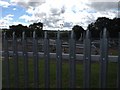
1
The Old Vicarage, north of Caldecott
Located off Uppingham Road in Rutland.
Image: © Mat Fascione
Taken: 15 Sep 2007
0.07 miles
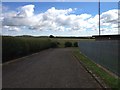
2
Transco gas grid station
Where the footpath south from Lyddington meets the A6003. View south to the Welland Valley
Image: © Tim Heaton
Taken: 29 Dec 2006
0.17 miles