IMAGES TAKEN NEAR TO
Harborough Road, MARKET HARBOROUGH, LE16 8NB
Introduction
This page details the photographs taken nearby to Harborough Road, LE16 8NB by members of the Geograph project.
The Geograph project started in 2005 with the aim of publishing, organising and preserving representative images for every square kilometre of Great Britain, Ireland and the Isle of Man.

There are currently over 7.5m images from over14,400 individuals and you can help contribute to the project by visiting https://www.geograph.org.uk
Image Map
Images are licensed for reuse under creativecommons.org/licenses/by-sa/2.0
Notes
- Clicking on the map will re-center to the selected point.
- The higher the marker number, the further away the image location is from the centre of the postcode.
Image Listing (7 Images Found)
Images are licensed for reuse under creativecommons.org/licenses/by-sa/2.0
Image
Details
Distance
1
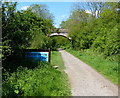
Waterloo Farm bridge
The Brampton Valley Way is heading north towards Market Harborough.
Image: © Mat Fascione
Taken: 25 May 2013
0.07 miles
2
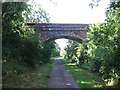
Bridge over Brampton Valley Way (National Cycle Route 6)
Image: © JThomas
Taken: 9 Aug 2014
0.07 miles
3
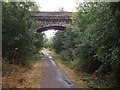
Brampton Valley Way near Great Oxendon
A bridge over the Brampton Valley Way near Great Oxendon.
Image: © Malc McDonald
Taken: 28 Jul 2018
0.07 miles
4
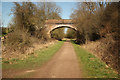
Waterloo Farm bridge
Bridge on NCN route 6 by Waterloo Farm
Image: © Richard Croft
Taken: 26 Mar 2012
0.08 miles
6
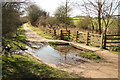
Brampton Valley Way
Ford on NCN route 6 near Great Oxendon
Image: © Richard Croft
Taken: 26 Mar 2012
0.15 miles
7
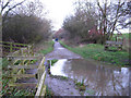
Trackbed of Old Railway near Great Oxendon
The former Northampton - Market Harborough railway, now a cycle path, to the north of Oxendon Tunnel. At this point the route crosses a culverted stream; heavy overnight rain has caused a sizeable pool of water to form - fortunately easily avoided by cyclists and walkers.
Image: © Stephen McKay
Taken: 30 Dec 2006
0.19 miles