IMAGES TAKEN NEAR TO
Harborough Road, MARKET HARBOROUGH, LE16 8LL
Introduction
This page details the photographs taken nearby to Harborough Road, LE16 8LL by members of the Geograph project.
The Geograph project started in 2005 with the aim of publishing, organising and preserving representative images for every square kilometre of Great Britain, Ireland and the Isle of Man.

There are currently over 7.5m images from over14,400 individuals and you can help contribute to the project by visiting https://www.geograph.org.uk
Image Map
Images are licensed for reuse under creativecommons.org/licenses/by-sa/2.0
Notes
- Clicking on the map will re-center to the selected point.
- The higher the marker number, the further away the image location is from the centre of the postcode.
Image Listing (10 Images Found)
Images are licensed for reuse under creativecommons.org/licenses/by-sa/2.0
Image
Details
Distance
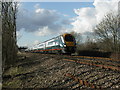
4
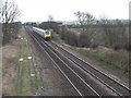
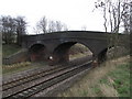
Railway track with approaching express
Railway track running S.E. towards Desborough. Express is beginning to slow as it approaches Market Harborough.
Image: © Richard Williams
Taken: 13 Feb 2007
0.14 miles
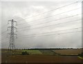
6
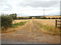
Farm track near Market Harborough
A track leading into a field near Market Harborough.
Image: © Malc McDonald
Taken: 28 Jul 2018
0.17 miles
7
Look Left.
Approaching express coming from the direction of Market Harborough.
Image: © Richard Williams
Taken: 9 Mar 2007
0.17 miles
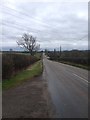
8
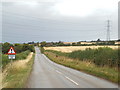
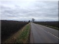
Harborough Road, near Braybrooke
Harborough Road near Braybrooke, looking towards Market Harborough.
Image: © Malc McDonald
Taken: 28 Jul 2018
0.19 miles