IMAGES TAKEN NEAR TO
Jordan Close, MARKET HARBOROUGH, LE16 8EW
Introduction
This page details the photographs taken nearby to Jordan Close, LE16 8EW by members of the Geograph project.
The Geograph project started in 2005 with the aim of publishing, organising and preserving representative images for every square kilometre of Great Britain, Ireland and the Isle of Man.

There are currently over 7.5m images from over14,400 individuals and you can help contribute to the project by visiting https://www.geograph.org.uk
Image Map
Images are licensed for reuse under creativecommons.org/licenses/by-sa/2.0
Notes
- Clicking on the map will re-center to the selected point.
- The higher the marker number, the further away the image location is from the centre of the postcode.
Image Listing (221 Images Found)
Images are licensed for reuse under creativecommons.org/licenses/by-sa/2.0
Image
Details
Distance
1
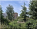
A bend in the Welland
The Welland here is firmly constrained between steel sheet piling and concrete cap stones. It is not allowed to break bounds the way it did in centuries past.
The building in the distance is the recent addition to Kettering Road, called Edwin Court.
Image: © Bob Harvey
Taken: 7 Aug 2022
0.04 miles
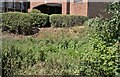
2
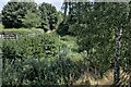
So much vegetation
I would love to get in there and work out just how many different plants are living with their feet in the river channel. It's easy to spot Bullrush and Great Willowherb, but there is a lot more in there.
Image: © Bob Harvey
Taken: 7 Aug 2022
0.05 miles
3
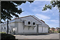
External refrigeration
The external condensers of the refrigeration units are mounted outside modern supermarkets. This is the rear of the Lidl store in Market Harborough
Image: © Bob Harvey
Taken: 7 Aug 2022
0.05 miles
4
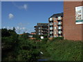
A car park
This is a paid carpark which styles itself the Welland Quarter car park. I imagine it is intended to be used by visitors to the multi-storey "retirement village" on the other side of the river. It is certainly missing from the local authorities list of car parks in the town (https://www.harborough.gov.uk/directory/13/car_parks/category/30 ), suggesting it is entirely a private enterprise. The car park is approached by a narrow road past the Lidl store from the roundabout on Kettering Road.
Amusingly, if you find this car park on Google Maps, the image supplied shows the parked cars submerged in flood waters up to the wheel rims. This sits at the confluence of the Rivers Jordan and Welland, both known for exceeding their bounds in time of rainfall.
Image: © Bob Harvey
Taken: 7 Aug 2022
0.05 miles
5

Road behind LIDL, Market Harborough
Following the meanderings of the River Welland.
Image: © Richard Vince
Taken: 18 Jan 2020
0.05 miles
6
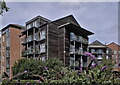
Retirement living
The two wooden-clad parts of the Retirement Village are called Chater House and Sence House
All of LHA's properties here are named after rivers, with only a superficial local connection. The Chater is part of the Welland Basin, and joins that river at Ketton near Stamford. The Sence is part of the Trent capture, and joins that river as part of the Tame.
This collection of buildings, styled a Retirement Community, is built on the site of the former railway line to Rugby closed in the Beeching era, and sadly missed.
Image: © Bob Harvey
Taken: 7 Aug 2022
0.06 miles
7
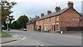
Terraced housing on Kettering Road
In Little Bowden, Leicestershire.
Image: © Mat Fascione
Taken: 8 Oct 2007
0.06 miles
8
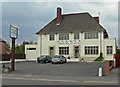
The Oat Hill
A public house and restaurant on Kettering Road in Little Bowden, Leicestershire.
Image: © Mat Fascione
Taken: 8 Oct 2007
0.06 miles
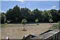
10
Overgrown river
The course of the Welland is very hard to spot here, the bed being dominated by summer plant growth.
Image: © Bob Harvey
Taken: 7 Aug 2022
0.07 miles