IMAGES TAKEN NEAR TO
Sandringham Way, MARKET HARBOROUGH, LE16 8EP
Introduction
This page details the photographs taken nearby to Sandringham Way, LE16 8EP by members of the Geograph project.
The Geograph project started in 2005 with the aim of publishing, organising and preserving representative images for every square kilometre of Great Britain, Ireland and the Isle of Man.

There are currently over 7.5m images from over14,400 individuals and you can help contribute to the project by visiting https://www.geograph.org.uk
Image Map
Images are licensed for reuse under creativecommons.org/licenses/by-sa/2.0
Notes
- Clicking on the map will re-center to the selected point.
- The higher the marker number, the further away the image location is from the centre of the postcode.
Image Listing (8 Images Found)
Images are licensed for reuse under creativecommons.org/licenses/by-sa/2.0
Image
Details
Distance
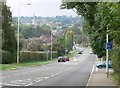
1

Kettering Road approaching Market Harborough through Little Bowden
The old route of the A6
Image: © Tim Heaton
Taken: 3 Oct 2022
0.14 miles
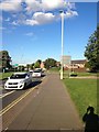
2
Kettering Road towards Market Harborough
The road is descending Clack Hill.
Image: © Mat Fascione
Taken: 8 Oct 2007
0.15 miles
3

Towards Market Harborough from Clack Hill
Image: © Andrew Tatlow
Taken: 19 Jun 2014
0.21 miles
5
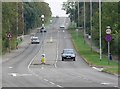
Kettering Road leaving Market Harborough
The road is climbing Clack Hill towards the A6, which is over the brow of the hill.
Image: © Mat Fascione
Taken: 8 Oct 2007
0.22 miles
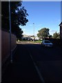
7
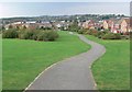
Little Bowden housing estate
A relatively new housing estate on the eastern edge of Market Harborough.
Image: © Mat Fascione
Taken: 8 Oct 2007
0.24 miles
