IMAGES TAKEN NEAR TO
Rosemoor Close, MARKET HARBOROUGH, LE16 8BA
Introduction
This page details the photographs taken nearby to Rosemoor Close, LE16 8BA by members of the Geograph project.
The Geograph project started in 2005 with the aim of publishing, organising and preserving representative images for every square kilometre of Great Britain, Ireland and the Isle of Man.

There are currently over 7.5m images from over14,400 individuals and you can help contribute to the project by visiting https://www.geograph.org.uk
Image Map
Images are licensed for reuse under creativecommons.org/licenses/by-sa/2.0
Notes
- Clicking on the map will re-center to the selected point.
- The higher the marker number, the further away the image location is from the centre of the postcode.
Image Listing (34 Images Found)
Images are licensed for reuse under creativecommons.org/licenses/by-sa/2.0
Image
Details
Distance
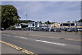
1
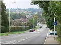
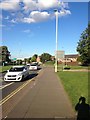
Kettering Road towards Market Harborough
The road is descending Clack Hill.
Image: © Mat Fascione
Taken: 8 Oct 2007
0.10 miles

4
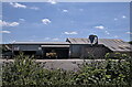
Sawmill
Glenmore timber specialises in converting whole trees to boards, and also imports and exports specialist hardwoods.
Image: © Bob Harvey
Taken: 7 Aug 2022
0.16 miles
5
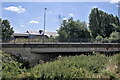
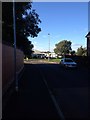
Rockingham Road bridge
The Welland passes under the road here.
Image: © Bob Harvey
Taken: 7 Aug 2022
0.19 miles
6
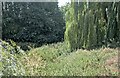
The Overgrown Welland
The river course hidden by weeds, as seen from the Western end of Image
Image: © Bob Harvey
Taken: 7 Aug 2022
0.19 miles
7
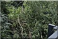
Somewhere in there
The desultory trickle of the River Welland is under there; this is the "view" of the river upstream of the Rockingham Road bridge Image When the rains come and the floods begin a lot of this vegetation, including the willow wands, will head off downstream and block something, perhaps even Image
Image: © Bob Harvey
Taken: 7 Aug 2022
0.19 miles
10
St Mary's Bridge - the deck.
The bridge, normally known as Rockingham Road Bridge, is named St. Mary's Bridge on the Ordnance Survey map. And, so far as I know, nowhere else. There is a Church of St Mary of Arden on the other side of the railway line, in Great Bowden Road. This was the parish church until the construction of St Dionysius in the town centre, in place of a chapel of St Mary.
Image: © Bob Harvey
Taken: 7 Aug 2022
0.19 miles